Aţ Ţārmīyah geodata
Aţ Ţārmīyah (Baghdad) is a seat of a second-order administrative division; located in Iraq in Asia/Baghdad (GMT+3) time zone. In our database, there are 71 cities with bigger population. Compared to other cities in Iraq, 59.2% of cities are located further ↑North; 54.9% of cities are located further →East and 66.2% of cities have higher elevation than Aţ Ţārmīyah. Note1


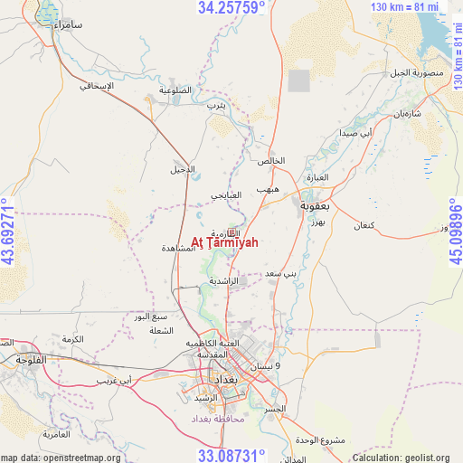
Aţ Ţārmīyah GPS coordinates[2]
33° 40' 27.984" North, 44° 23' 44.988" East
| Map corner | latitude | longitude |
|---|---|---|
| Upper-left | 34.25759°, | 43.69271° |
| Center: | 33.67444°, | 44.39583° |
| Lower-right: | 33.08731°, | 45.09896° |
| Map W x H: | 130.1×130.1 km | = 80.8×80.8mi |
| max Lat: | 37.22781° ⇑59.2% North |
| Aţ Ţārmīyah: | 33.67444° |
| min Lat: | ⇓40.8% South 29.97421° |
| min Long | Aţ Ţārmīyah | max Long |
| 40.28586° | 44.39583° | 48.47309° |
| W 45.1%⇐ | ⇒54.9% E |
Elevation
Elevation of Aţ Ţārmīyah is 41 m = 135 ft, and this is 252 m = 827 ft below average elevation for this country.
| Max E: |
1316 m = 4318 ft | 66.2% |
| Avg. | 293 m = 961 ft | |
| Aţ Ţārmīyah | 41 m = 135 ft | |
Min E: |
1 m = 3 ft | 33.8% |
See also: Iraq elevation on elevation.city.
Geographical zone
Aţ Ţārmīyah is located in North temperate zone (between Tropic of Cancer and the Arctic Circle). Distance of this Northern Tropic circle is 1138.3 km =707.3 mi to South.| Distance of | km | miles | from Aţ Ţārmīyah |
|---|---|---|---|
| North Pole | 6262.8 | 3891.5 | to North |
| Arctic Circle | 3656.9 | 2272.3 | to North |
| Tropic Cancer | 1138.3 | 707.3 | to South |
| Equator | 3744.2 | 2326.5 | to South |


Nearby cities:
15 places around Aţ Ţārmīyah: (largest is in red/bold)
• Abū Ghurayb
45.4 km =28.2 mi,  205°
205°
• Ad Dawr
103.1 km =64.1 mi,  327°
327°
• Ad Dujayl
24.3 km =15.1 mi,  322°
322°
• Al Fallūjah
67.1 km =41.7 mi,  237°
237°
• Al Khāliş
22.8 km =14.2 mi,  30°
30°
• Al Maḩmūdīyah
68.1 km =42.3 mi,  182°
182°
• Al Miqdādīyah
60.3 km =37.5 mi,  55°
55°
• Al Musayyib
100.1 km =62.2 mi,  185°
185°
• Aş Şuwayrah
90.4 km =56.2 mi,  157°
157°
• Baghdad
37.1 km =23.1 mi, 179°
• Balad
44.3 km =27.5 mi, 328°
• Baladrūz
63.1 km =39.2 mi,  87°
87°
• Baqubah
21.3 km =13.2 mi,  65°
65°
• Khāliş
19.6 km =12.2 mi,  40°
40°
• Sāmarrā’
74.7 km =46.4 mi, 320°
Sources, notices
• [Note1] Compared only with cities in Iraq existing in our database
• [Src1] Map data: © OpenStreetMap contributors (CC-BY-SA)
• [Src2] Other city data from geonames.org with taken over terms of usage.
• [Src3] Geographical zone / Annual Mean Temperature by Robert A. Rohde @ Wikipedia
