Baqubah geodata
Baqubah (Diyālá) is a seat of a first-order administrative division; located in Iraq in Asia/Baghdad (GMT+3) time zone. With population of 152,550 people, there are 21 cities with bigger population in this country. Compared to other cities in Iraq, 57% of cities are located further ↑North; 56.3% of cities are located further ←West and 60.6% of cities have higher elevation than Baqubah. Note1


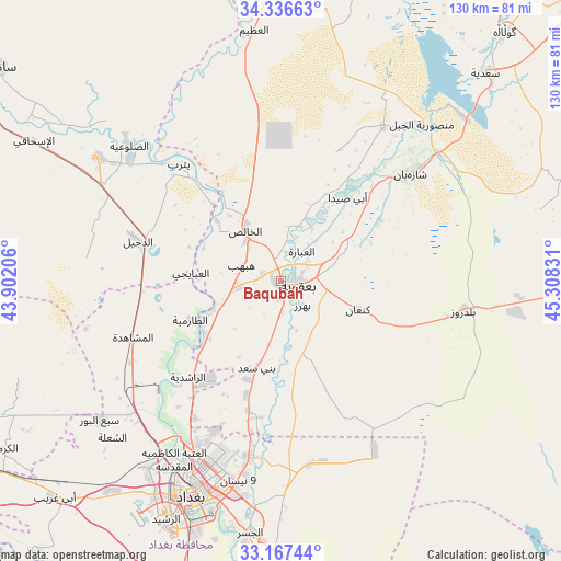
Baqubah GPS coordinates[2]
33° 45' 14.508" North, 44° 36' 18.648" East
| Map corner | latitude | longitude |
|---|---|---|
| Upper-left | 34.33663°, | 43.90206° |
| Center: | 33.75403°, | 44.60518° |
| Lower-right: | 33.16744°, | 45.30831° |
| Map W x H: | 130×130 km | = 80.8×80.8mi |
| max Lat: | 37.22781° ⇑57% North |
| Baqubah: | 33.75403° |
| min Lat: | ⇓43% South 29.97421° |
| min Long | Baqubah | max Long |
| 40.28586° | 44.60518° | 48.47309° |
| W 56.3%⇐ | ⇒43.7% E |
Elevation
Elevation of Baqubah is 48 m = 157 ft, and this is 245 m = 804 ft below average elevation for this country.
| Max E: |
1316 m = 4318 ft | 60.6% |
| Avg. | 293 m = 961 ft | |
| Baqubah | 48 m = 157 ft | |
Min E: |
1 m = 3 ft | 39.4% |
See also: Baqubah elevation on elevation.city.
Geographical zone
Baqubah is located in North temperate zone (between Tropic of Cancer and the Arctic Circle). Distance of this Northern Tropic circle is 1147.2 km =712.8 mi to South.| Distance of | km | miles | from Baqubah |
|---|---|---|---|
| North Pole | 6254 | 3886.1 | to North |
| Arctic Circle | 3648.1 | 2266.8 | to North |
| Tropic Cancer | 1147.2 | 712.8 | to South |
| Equator | 3753.1 | 2332.1 | to South |


Nearby cities:
15 places around Baqubah: (largest is in red/bold)
• Abū Ghurayb
63.3 km =39.3 mi,  218°
218°
• Ad Dujayl
35.8 km =22.2 mi,  286°
286°
• Al Fallūjah
88.3 km =54.9 mi,  239°
239°
• Al Khāliş
13.3 km =8.3 mi,  324°
324°
• Al Maḩmūdīyah
80.1 km =49.8 mi,  196°
196°
• Al Miqdādīyah
39.5 km =24.5 mi,  50°
50°
• Aş Şuwayrah
93.5 km =58.1 mi,  170°
170°
• Aţ Ţārmīyah
21.3 km =13.2 mi,  245°
245°
• Baghdad
49.7 km =30.9 mi, 202°
• Balad
51.4 km =31.9 mi,  304°
304°
• Baladrūz
44.2 km =27.5 mi,  98°
98°
• Khāliş
8.9 km =5.5 mi,  312°
312°
• Khānaqīn
98 km =60.9 mi, 47°
• Mandalī
87.8 km =54.6 mi,  90°
90°
• Sāmarrā’
82.6 km =51.3 mi, 306°
Sources, notices
• [Note1] Compared only with cities in Iraq existing in our database
• [Src1] Map data: © OpenStreetMap contributors (CC-BY-SA)
• [Src2] Other city data from geonames.org with taken over terms of usage.
• [Src3] Geographical zone / Annual Mean Temperature by Robert A. Rohde @ Wikipedia
