Al Fallūjah geodata
Al Fallūjah (Anbar) is a seat of a second-order administrative division; located in Iraq in Asia/Baghdad (GMT+3) time zone. With population of 190,159 people, there are 18 cities with bigger population in this country. Compared to other cities in Iraq, 61.3% of cities are located further ↑North; 71.8% of cities are located further →East and 62% of cities have higher elevation than Al Fallūjah. Note1


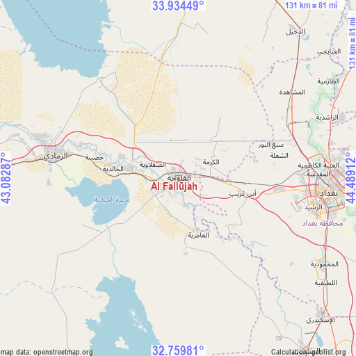
Al Fallūjah GPS coordinates[2]
33° 20' 56.868" North, 43° 47' 9.564" East
| Map corner | latitude | longitude |
|---|---|---|
| Upper-left | 33.93449°, | 43.08287° |
| Center: | 33.34913°, | 43.78599° |
| Lower-right: | 32.75981°, | 44.48912° |
| Map W x H: | 130.6×130.6 km | = 81.2×81.2mi |
| max Lat: | 37.22781° ⇑61.3% North |
| Al Fallūjah: | 33.34913° |
| min Lat: | ⇓38.7% South 29.97421° |
| min Long | Al Fallūjah | max Long |
| 40.28586° | 43.78599° | 48.47309° |
| W 28.2%⇐ | ⇒71.8% E |
Elevation
Elevation of Al Fallūjah is 45 m = 148 ft, and this is 248 m = 814 ft below average elevation for this country.
| Max E: |
1316 m = 4318 ft | 62% |
| Avg. | 293 m = 961 ft | |
| Al Fallūjah | 45 m = 148 ft | |
Min E: |
1 m = 3 ft | 38% |
See also: Al Fallūjah elevation on elevation.city.
Geographical zone
Al Fallūjah is located in North temperate zone (between Tropic of Cancer and the Arctic Circle). Distance of this Northern Tropic circle is 1102.2 km =684.9 mi to South.| Distance of | km | miles | from Al Fallūjah |
|---|---|---|---|
| North Pole | 6299 | 3914 | to North |
| Arctic Circle | 3693.1 | 2294.8 | to North |
| Tropic Cancer | 1102.2 | 684.9 | to South |
| Equator | 3708.1 | 2304.1 | to South |


Nearby cities:
15 places around Al Fallūjah: (largest is in red/bold)
• Abū Ghurayb
37.4 km =23.2 mi,  97°
97°
• Ad Dujayl
69.2 km =43 mi,  36°
36°
• Al Khāliş
88 km =54.7 mi,  50°
50°
• Al Maḩmūdīyah
62.7 km =39 mi,  120°
120°
• Al Musayyib
78.9 km =49 mi,  143°
143°
• Aţ Ţārmīyah
67.1 km =41.7 mi,  57°
57°
• Baghdad
57.1 km =35.5 mi,  90°
90°
• Balad
81.2 km =50.5 mi,  24°
24°
• Baqubah
88.3 km =54.9 mi, 59°
• Hīt
94.4 km =58.7 mi,  289°
289°
• Karbala
84.5 km =52.5 mi,  164°
164°
• Khāliş
86 km =53.4 mi, 53°
• Nāḩīyat Saddat al Hindīyah
84.1 km =52.3 mi,  146°
146°
• Ramadi
45.1 km =28 mi,  280°
280°
• ‘Ayn Tamr
91.3 km =56.7 mi,  197°
197°
In other languages:
- In Spanish: Faluya
- In France: Falloujah
- In German: Falludscha
- In Italian: Falluja
Sources, notices
• [Note1] Compared only with cities in Iraq existing in our database
• [Src1] Map data: © OpenStreetMap contributors (CC-BY-SA)
• [Src2] Other city data from geonames.org with taken over terms of usage.
• [Src3] Geographical zone / Annual Mean Temperature by Robert A. Rohde @ Wikipedia
