Al ‘Awjah geodata
Al ‘Awjah (Salah ad Din) is a seat of a third-order administrative division; located in Iraq in Asia/Baghdad (GMT+3) time zone. In our database, there are 71 cities with bigger population. Compared to other cities in Iraq, 53.5% of cities are located further ↓South; 73.2% of cities are located further →East and 54.9% of cities have higher elevation than Al ‘Awjah. Note1


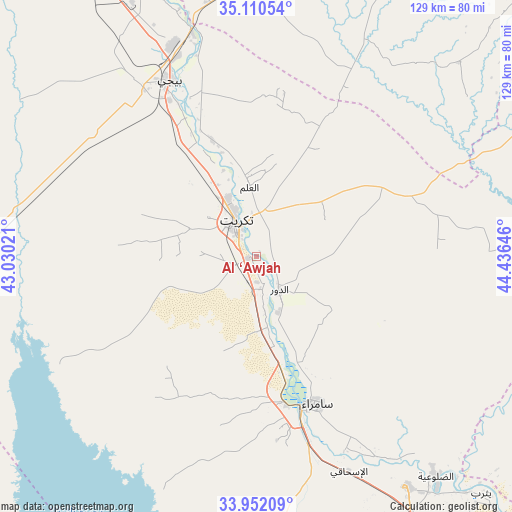
Al ‘Awjah GPS coordinates[2]
34° 31' 59.988" North, 43° 43' 59.988" East
| Map corner | latitude | longitude |
|---|---|---|
| Upper-left | 35.11054°, | 43.03021° |
| Center: | 34.53333°, | 43.73333° |
| Lower-right: | 33.95209°, | 44.43646° |
| Map W x H: | 128.8×128.8 km | = 80×80mi |
| max Lat: | 37.22781° ⇑46.5% North |
| Al ‘Awjah: | 34.53333° |
| min Lat: | ⇓53.5% South 29.97421° |
| min Long | Al ‘Awjah | max Long |
| 40.28586° | 43.73333° | 48.47309° |
| W 26.8%⇐ | ⇒73.2% E |
Elevation
Elevation of Al ‘Awjah is 77 m = 253 ft, and this is 216 m = 709 ft below average elevation for this country.
| Max E: |
1316 m = 4318 ft | 54.9% |
| Avg. | 293 m = 961 ft | |
| Al ‘Awjah | 77 m = 253 ft | |
Min E: |
1 m = 3 ft | 45.1% |
See also: Iraq elevation on elevation.city.
Geographical zone
Al ‘Awjah is located in North temperate zone (between Tropic of Cancer and the Arctic Circle). Distance of this Northern Tropic circle is 1233.8 km =766.6 mi to South.| Distance of | km | miles | from Al ‘Awjah |
|---|---|---|---|
| North Pole | 6167.3 | 3832.2 | to North |
| Arctic Circle | 3561.4 | 2213 | to North |
| Tropic Cancer | 1233.8 | 766.6 | to South |
| Equator | 3839.7 | 2385.9 | to South |


Nearby cities:
15 places around Al ‘Awjah: (largest is in red/bold)
• Ad Dawr
10.2 km =6.3 mi,  147°
147°
• Ad Dujayl
89.2 km =55.4 mi, 148°
• Al Khāliş
104.9 km =65.2 mi,  136°
136°
• Al Ḩawījah
88.2 km =54.8 mi,  2°
2°
• Al ‘Abbāsī
83.4 km =51.8 mi,  351°
351°
• Ar Riyāḑ
83.5 km =51.9 mi,  11°
11°
• Aţ Ţārmīyah
113.3 km =70.4 mi, 147°
• Balad
69 km =42.9 mi, 146°
• Bayjī
49.4 km =30.7 mi,  333°
333°
• Dāqūq
93.8 km =58.3 mi,  44°
44°
• Khāliş
109.2 km =67.9 mi, 137°
• Kifrī
113.6 km =70.6 mi,  81°
81°
• Sāmarrā’
40 km =24.9 mi,  159°
159°
• Tikrīt
10.5 km =6.5 mi, 331°
• Tozkhurmato
91.2 km =56.7 mi,  64°
64°
Sources, notices
• [Note1] Compared only with cities in Iraq existing in our database
• [Src1] Map data: © OpenStreetMap contributors (CC-BY-SA)
• [Src2] Other city data from geonames.org with taken over terms of usage.
• [Src3] Geographical zone / Annual Mean Temperature by Robert A. Rohde @ Wikipedia
