Balad geodata
Balad (Salah ad Din) is a seat of a second-order administrative division; located in Iraq in Asia/Baghdad (GMT+3) time zone. With population of 42,088 people, there are 46 cities with bigger population in this country. Compared to other cities in Iraq, 53.5% of cities are located further ↑North; 62.7% of cities are located further →East and 59.2% of cities have higher elevation than Balad. Note1


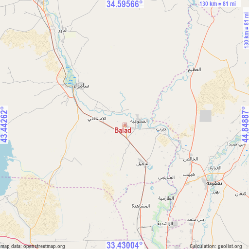
Balad GPS coordinates[2]
34° 0' 53.46" North, 44° 8' 44.664" East
| Map corner | latitude | longitude |
|---|---|---|
| Upper-left | 34.59566°, | 43.44262° |
| Center: | 34.01485°, | 44.14574° |
| Lower-right: | 33.43004°, | 44.84887° |
| Map W x H: | 129.6×129.6 km | = 80.5×80.5mi |
| max Lat: | 37.22781° ⇑53.5% North |
| Balad: | 34.01485° |
| min Lat: | ⇓46.5% South 29.97421° |
| min Long | Balad | max Long |
| 40.28586° | 44.14574° | 48.47309° |
| W 37.3%⇐ | ⇒62.7% E |
Elevation
Elevation of Balad is 53 m = 174 ft, and this is 240 m = 787 ft below average elevation for this country.
| Max E: |
1316 m = 4318 ft | 59.2% |
| Avg. | 293 m = 961 ft | |
| Balad | 53 m = 174 ft | |
Min E: |
1 m = 3 ft | 40.8% |
See also: Balad elevation on elevation.city.
Geographical zone
Balad is located in North temperate zone (between Tropic of Cancer and the Arctic Circle). Distance of this Northern Tropic circle is 1176.2 km =730.9 mi to South.| Distance of | km | miles | from Balad |
|---|---|---|---|
| North Pole | 6225 | 3868 | to North |
| Arctic Circle | 3619.1 | 2248.8 | to North |
| Tropic Cancer | 1176.2 | 730.9 | to South |
| Equator | 3782.1 | 2350.1 | to South |


Nearby cities:
15 places around Balad: (largest is in red/bold)
• Abū Ghurayb
78.9 km =49 mi,  177°
177°
• Ad Dawr
58.8 km =36.5 mi,  326°
326°
• Ad Dujayl
20.4 km =12.7 mi,  156°
156°
• Al Fallūjah
81.2 km =50.5 mi,  204°
204°
• Al Khāliş
39.1 km =24.3 mi,  117°
117°
• Al Miqdādīyah
73 km =45.4 mi,  93°
93°
• Al ‘Awjah
69 km =42.9 mi, 326°
• Aţ Ţārmīyah
44.3 km =27.5 mi,  148°
148°
• Baghdad
78.6 km =48.8 mi, 162°
• Baladrūz
93.1 km =57.8 mi,  112°
112°
• Baqubah
51.4 km =31.9 mi, 124°
• Khāliş
42.5 km =26.4 mi, 122°
• Ramadi
101.8 km =63.3 mi,  229°
229°
• Sāmarrā’
31.3 km =19.4 mi,  310°
310°
• Tikrīt
79.4 km =49.3 mi, 327°
Sources, notices
• [Note1] Compared only with cities in Iraq existing in our database
• [Src1] Map data: © OpenStreetMap contributors (CC-BY-SA)
• [Src2] Other city data from geonames.org with taken over terms of usage.
• [Src3] Geographical zone / Annual Mean Temperature by Robert A. Rohde @ Wikipedia
