Sinjār geodata
Sinjār (Nineveh) is a seat of a second-order administrative division; located in Iraq in Asia/Baghdad (GMT+3) time zone. With population of 38,294 people, there are 47 cities with bigger population in this country. Compared to other cities in Iraq, 83.8% of cities are located further ↓South; 97.9% of cities are located further →East and 78.2% of cities have lower elevation than Sinjār. Note1


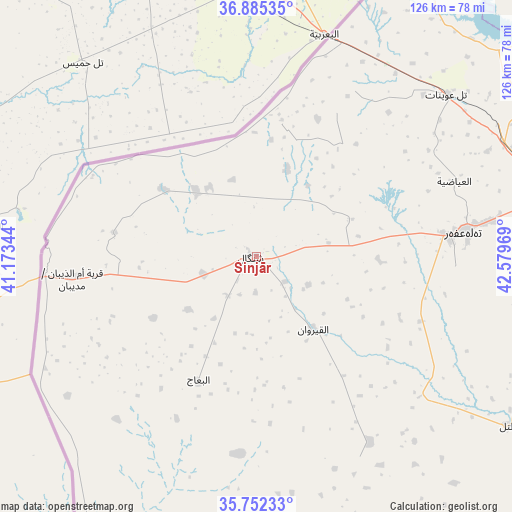
Sinjār GPS coordinates[2]
36° 19' 15.24" North, 41° 52' 35.616" East
| Map corner | latitude | longitude |
|---|---|---|
| Upper-left | 36.88535°, | 41.17344° |
| Center: | 36.3209°, | 41.87656° |
| Lower-right: | 35.75233°, | 42.57969° |
| Map W x H: | 126×126 km | = 78.3×78.3mi |
| max Lat: | 37.22781° ⇑16.2% North |
| Sinjār: | 36.3209° |
| min Lat: | ⇓83.8% South 29.97421° |
| min Long | Sinjār | max Long |
| 40.28586° | 41.87656° | 48.47309° |
| W 2.1%⇐ | ⇒97.9% E |
Elevation
Elevation of Sinjār is 517 m = 1696 ft, and this is 224 m = 735 ft above average elevation for this country.
| Max E: |
1316 m = 4318 ft | 21.8% |
| Sinjār | 517 m 1696 ft | |
| Avg. | 293 m = 961 ft | |
Min E: |
1 m = 3 ft | 78.2% |
See also: Iraq elevation on elevation.city.
Geographical zone
Sinjār is located in North temperate zone (between Tropic of Cancer and the Arctic Circle). Distance of this Northern Tropic circle is 1432.6 km =890.2 mi to South.| Distance of | km | miles | from Sinjār |
|---|---|---|---|
| North Pole | 5968.6 | 3708.7 | to North |
| Arctic Circle | 3362.7 | 2089.5 | to North |
| Tropic Cancer | 1432.6 | 890.2 | to South |
| Equator | 4038.5 | 2509.4 | to South |


Nearby cities:
15 places around Sinjār: (largest is in red/bold)
• Al Ba‘āj
34.1 km =21.2 mi,  204°
204°
• Al Mawşil al Jadīdah
110.1 km =68.4 mi,  89°
89°
• Al Ḩaḑar
113.5 km =70.5 mi,  137°
137°
• Al-Hamdaniya
134.6 km =83.6 mi, 92°
• Derkar
129.1 km =80.2 mi,  40°
40°
• Dihok
116.4 km =72.3 mi,  58°
58°
• Ibrāhīm al Khalīl
110 km =68.4 mi,  34°
34°
• Mosul
111.3 km =69.2 mi, 89°
• Saymayl
105.3 km =65.4 mi, 55°
• Sīnah
117.1 km =72.8 mi, 62°
• Tall ‘Afar
51.6 km =32.1 mi,  82°
82°
• Tallkayf
113 km =70.2 mi, 80°
• Zaxo
116.9 km =72.6 mi, 38°
• Zaxu
116.2 km =72.2 mi, 38°
• Zāwītah
130.5 km =81.1 mi, 60°
Sources, notices
• [Note1] Compared only with cities in Iraq existing in our database
• [Src1] Map data: © OpenStreetMap contributors (CC-BY-SA)
• [Src2] Other city data from geonames.org with taken over terms of usage.
• [Src3] Geographical zone / Annual Mean Temperature by Robert A. Rohde @ Wikipedia
