Al-Hamdaniya geodata
Al-Hamdaniya (Nineveh) is a populated place; located in Iraq in Asia/Baghdad (GMT+3) time zone. With population of 50,000 people, there are 39 cities with bigger population in this country. Compared to other cities in Iraq, 80.3% of cities are located further ↓South; 79.6% of cities are located further →East and 64.8% of cities have lower elevation than Al-Hamdaniya. Note1


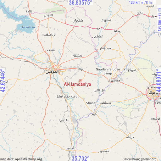
Al-Hamdaniya GPS coordinates[2]
36° 16' 15.348" North, 43° 22' 39.288" East
| Map corner | latitude | longitude |
|---|---|---|
| Upper-left | 36.83575°, | 42.67446° |
| Center: | 36.27093°, | 43.37758° |
| Lower-right: | 35.702°, | 44.08071° |
| Map W x H: | 126.1×126.1 km | = 78.4×78.4mi |
| max Lat: | 37.22781° ⇑19.7% North |
| Al-Hamdaniya: | 36.27093° |
| min Lat: | ⇓80.3% South 29.97421° |
| min Long | Al-Hamdaniya | max Long |
| 40.28586° | 43.37758° | 48.47309° |
| W 20.4%⇐ | ⇒79.6% E |
Elevation
Elevation of Al-Hamdaniya is 274 m = 899 ft, and this is 19 m = 62 ft below average elevation for this country.
| Max E: |
1316 m = 4318 ft | 35.2% |
| Avg. | 293 m = 961 ft | |
| Al-Hamdaniya | 274 m = 899 ft | |
Min E: |
1 m = 3 ft | 64.8% |
See also: Al-Hamdaniya elevation on elevation.city.
Geographical zone
Al-Hamdaniya is located in North temperate zone (between Tropic of Cancer and the Arctic Circle). Distance of this Northern Tropic circle is 1427 km =886.7 mi to South.| Distance of | km | miles | from Al-Hamdaniya |
|---|---|---|---|
| North Pole | 5974.1 | 3712.1 | to North |
| Arctic Circle | 3368.2 | 2092.9 | to North |
| Tropic Cancer | 1427 | 886.7 | to South |
| Equator | 4032.9 | 2505.9 | to South |


Nearby cities:
15 places around Al-Hamdaniya: (largest is in red/bold)
• Al Mawşil al Jadīdah
25.3 km =15.7 mi,  285°
285°
• Al Qayyārah
53 km =32.9 mi,  188°
188°
• Ash Shaykhān
47.3 km =29.4 mi,  357°
357°
• Beḧirke
59.2 km =36.8 mi,  85°
85°
• Dare Tû
63.4 km =39.4 mi,  105°
105°
• Erbil
57.7 km =35.9 mi,  99°
99°
• Kasnazān
68.2 km =42.4 mi, 96°
• Mexmur
57.9 km =36 mi,  161°
161°
• Mosul
24.3 km =15.1 mi, 287°
• Qushtepe
66.4 km =41.3 mi,  116°
116°
• Sīnah
67 km =41.6 mi,  333°
333°
• Tallkayf
33.6 km =20.9 mi,  316°
316°
• Xebat
26.3 km =16.3 mi, 88°
• ‘Aqrah
71.4 km =44.4 mi,  40°
40°
• ‘Aynkāwah
55.5 km =34.5 mi, 94°
Sources, notices
• [Note1] Compared only with cities in Iraq existing in our database
• [Src1] Map data: © OpenStreetMap contributors (CC-BY-SA)
• [Src2] Other city data from geonames.org with taken over terms of usage.
• [Src3] Geographical zone / Annual Mean Temperature by Robert A. Rohde @ Wikipedia
