Varāmīn geodata
Varāmīn (Tehrān) is a seat of a second-order administrative division; located in Iran in Asia/Tehran (GMT+3.5) time zone. With population of 179,603 people, there are 42 cities with bigger population in this country. Compared to other cities in Iran, 61.2% of cities are located further ↓South; 56.2% of cities are located further ←West and 62.8% of cities have higher elevation than Varāmīn. Note1


Varāmīn GPS coordinates[2]
35° 19' 27.12" North, 51° 38' 44.52" East
| Map corner | latitude | longitude |
|---|---|---|
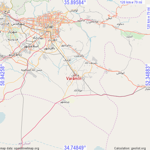
| Upper-left | 35.89584°, | 50.94258° |
| Center: | 35.3242°, | 51.6457° |
| Lower-right: | 34.74849°, | 52.34883° |
| Map W x H: | 127.6×127.6 km | = 79.3×79.3mi |
| max Lat: | 39.6482° ⇑38.8% North |
| Varāmīn: | 35.3242° |
| min Lat: | ⇓61.2% South 25.2919° |
| min Long | Varāmīn | max Long |
| 44.38416° | 51.6457° | 61.9965° |
| W 56.2%⇐ | ⇒43.8% E |
Elevation
Elevation of Varāmīn is 920 m = 3018 ft, and this is 129 m = 423 ft below average elevation for this country.
| Max E: |
2564 m = 8412 ft | 62.8% |
| Avg. | 1049 m = 3442 ft | |
| Varāmīn | 920 m = 3018 ft | |
Min E: |
-24 m = -79 ft | 37.2% |
See also: Varāmīn elevation on elevation.city.
Geographical zone
Varāmīn is located in North temperate zone (between Tropic of Cancer and the Arctic Circle). Distance of this Northern Tropic circle is 1321.8 km =821.3 mi to South.| Distance of | km | miles | from Varāmīn |
|---|---|---|---|
| North Pole | 6079.4 | 3777.6 | to North |
| Arctic Circle | 3473.5 | 2158.3 | to North |
| Tropic Cancer | 1321.8 | 821.3 | to South |
| Equator | 3927.7 | 2440.6 | to South |


Nearby cities:
15 places around Varāmīn: (largest is in red/bold)
• Damāvand
58.2 km =36.2 mi,  41°
41°
• Eqbālīyeh
10.3 km =6.4 mi,  256°
256°
• Eslāmshahr
45 km =28 mi,  304°
304°
• Garmsār
64.2 km =39.9 mi,  100°
100°
• Pākdasht
17.5 km =10.9 mi,  11°
11°
• Pīshvā
7.6 km =4.7 mi, 103°
• Qarchak
13.2 km =8.2 mi,  331°
331°
• Rey
35.3 km =21.9 mi, 328°
• Robāţ Karīm
54 km =33.6 mi,  289°
289°
• Shahrak-e Emām Ḩasan
32.8 km =20.4 mi, 303°
• Sharīfābād
17.1 km =10.6 mi,  47°
47°
• Tajrīsh
57 km =35.4 mi,  339°
339°
• Tehran
45.9 km =28.5 mi, 333°
• Īstgāh-e Rāh Āhan-e Garmsār
61.1 km =38 mi, 99°
• Ţāleb ābād
22.2 km =13.8 mi, 332°
Sources, notices
• [Note1] Compared only with cities in Iran existing in our database
• [Src1] Map data: © OpenStreetMap contributors (CC-BY-SA)
• [Src2] Other city data from geonames.org with taken over terms of usage.
• [Src3] Geographical zone / Annual Mean Temperature by Robert A. Rohde @ Wikipedia
