Sharīfābād geodata
Sharīfābād (Tehrān) is a populated place; located in Iran in Asia/Tehran (GMT+3.5) time zone. With population of 8,870 people, there are 207 cities with bigger population in this country. Compared to other cities in Iran, 61.7% of cities are located further ↓South; 57.8% of cities are located further ←West and 55.6% of cities have higher elevation than Sharīfābād. Note1


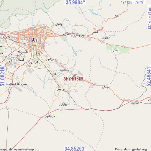
Sharīfābād GPS coordinates[2]
35° 25' 39" North, 51° 47' 7.008" East
| Map corner | latitude | longitude |
|---|---|---|
| Upper-left | 35.9984°, | 51.08216° |
| Center: | 35.4275°, | 51.78528° |
| Lower-right: | 34.85253°, | 52.48841° |
| Map W x H: | 127.4×127.4 km | = 79.2×79.2mi |
| max Lat: | 39.6482° ⇑38.3% North |
| Sharīfābād: | 35.4275° |
| min Lat: | ⇓61.7% South 25.2919° |
| min Long | Sharīfābād | max Long |
| 44.38416° | 51.78528° | 61.9965° |
| W 57.8%⇐ | ⇒42.2% E |
Elevation
Elevation of Sharīfābād is 1056 m = 3465 ft, and this is 7 m = 23 ft above average elevation for this country.
| Max E: |
2564 m = 8412 ft | 55.6% |
| Sharīfābād | 1056 m 3465 ft | |
| Avg. | 1049 m = 3442 ft | |
Min E: |
-24 m = -79 ft | 44.4% |
See also: Iran elevation on elevation.city.
Geographical zone
Sharīfābād is located in North temperate zone (between Tropic of Cancer and the Arctic Circle). Distance of this Northern Tropic circle is 1333.2 km =828.4 mi to South.| Distance of | km | miles | from Sharīfābād |
|---|---|---|---|
| North Pole | 6067.9 | 3770.4 | to North |
| Arctic Circle | 3462 | 2151.2 | to North |
| Tropic Cancer | 1333.2 | 828.4 | to South |
| Equator | 3939.2 | 2447.7 | to South |


Nearby cities:
15 places around Sharīfābād: (largest is in red/bold)
• Damāvand
41.3 km =25.7 mi,  38°
38°
• Eqbālīyeh
26.6 km =16.5 mi,  238°
238°
• Eslāmshahr
51.7 km =32.1 mi,  285°
285°
• Garmsār
55.5 km =34.5 mi,  114°
114°
• Pākdasht
10.8 km =6.7 mi,  301°
301°
• Pīshvā
14.3 km =8.9 mi,  201°
201°
• Qarchak
19 km =11.8 mi,  270°
270°
• Rey
36.3 km =22.6 mi, 300°
• Robāţ Karīm
63.9 km =39.7 mi,  275°
275°
• Shahrak-e Emām Ḩasan
40.4 km =25.1 mi, 279°
• Tajrīsh
53 km =32.9 mi,  322°
322°
• Tehran
44.3 km =27.5 mi,  312°
312°
• Varāmīn
17.1 km =10.6 mi,  227°
227°
• Īstgāh-e Rāh Āhan-e Garmsār
52.2 km =32.4 mi, 114°
• Ţāleb ābād
24.4 km =15.2 mi, 289°
Sources, notices
• [Note1] Compared only with cities in Iran existing in our database
• [Src1] Map data: © OpenStreetMap contributors (CC-BY-SA)
• [Src2] Other city data from geonames.org with taken over terms of usage.
• [Src3] Geographical zone / Annual Mean Temperature by Robert A. Rohde @ Wikipedia
