Nā’īn geodata
Nā’īn (Isfahan) is a seat of a second-order administrative division; located in Iran in Asia/Tehran (GMT+3.5) time zone. In our database, there are 232 cities with bigger population. Compared to other cities in Iran, 61.9% of cities are located further ↑North; 66% of cities are located further ←West and 73.9% of cities have lower elevation than Nā’īn. Note1


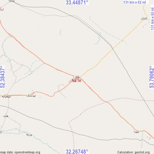
Nā’īn GPS coordinates[2]
32° 51' 36.216" North, 53° 5' 14.964" East
| Map corner | latitude | longitude |
|---|---|---|
| Upper-left | 33.44871°, | 52.38437° |
| Center: | 32.86006°, | 53.08749° |
| Lower-right: | 32.26748°, | 53.79062° |
| Map W x H: | 131.3×131.3 km | = 81.6×81.6mi |
| max Lat: | 39.6482° ⇑61.9% North |
| Nā’īn: | 32.86006° |
| min Lat: | ⇓38.1% South 25.2919° |
| min Long | Nā’īn | max Long |
| 44.38416° | 53.08749° | 61.9965° |
| W 66%⇐ | ⇒34% E |
Elevation
Elevation of Nā’īn is 1564 m = 5131 ft, and this is 515 m = 1690 ft above average elevation for this country.
| Max E: |
2564 m = 8412 ft | 26.1% |
| Nā’īn | 1564 m 5131 ft | |
| Avg. | 1049 m = 3442 ft | |
Min E: |
-24 m = -79 ft | 73.9% |
See also: Iran elevation on elevation.city.
Geographical zone
Nā’īn is located in North temperate zone (between Tropic of Cancer and the Arctic Circle). Distance of this Northern Tropic circle is 1047.8 km =651.1 mi to South.| Distance of | km | miles | from Nā’īn |
|---|---|---|---|
| North Pole | 6353.4 | 3947.8 | to North |
| Arctic Circle | 3747.5 | 2328.6 | to North |
| Tropic Cancer | 1047.8 | 651.1 | to South |
| Equator | 3653.7 | 2270.3 | to South |


Nearby cities:
15 places around Nā’īn: (largest is in red/bold)
• Abrīsham
145.6 km =90.5 mi,  256°
256°
• Ardakān
106.4 km =66.1 mi,  125°
125°
• Ardestān
88.1 km =54.7 mi,  310°
310°
• Dorcheh Pīāz
145.8 km =90.6 mi, 259°
• Dowlatābād
130.2 km =80.9 mi,  267°
267°
• Falāvarjān
151.5 km =94.1 mi, 257°
• Isfahan
134.1 km =83.3 mi, 260°
• Kelīshād va Sūdarjān
149.9 km =93.1 mi, 256°
• Khavāş Kūh
82.6 km =51.3 mi,  138°
138°
• Khomeynī Shahr
146.3 km =90.9 mi, 262°
• Meybod
110.4 km =68.6 mi, 127°
• Naţanz
130.7 km =81.2 mi,  303°
303°
• Rehnān
140.3 km =87.2 mi, 261°
• Shahreẕā
148.6 km =92.3 mi,  230°
230°
• Shāhīn Shahr
143.3 km =89 mi, 269°
Sources, notices
• [Note1] Compared only with cities in Iran existing in our database
• [Src1] Map data: © OpenStreetMap contributors (CC-BY-SA)
• [Src2] Other city data from geonames.org with taken over terms of usage.
• [Src3] Geographical zone / Annual Mean Temperature by Robert A. Rohde @ Wikipedia
