Meybod geodata
Meybod (Yazd) is a seat of a second-order administrative division; located in Iran in Asia/Tehran (GMT+3.5) time zone. With population of 51,874 people, there are 123 cities with bigger population in this country. Compared to other cities in Iran, 68.3% of cities are located further ↑North; 71% of cities are located further ←West and 54.4% of cities have higher elevation than Meybod. Note1


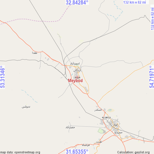
Meybod GPS coordinates[2]
32° 15' 0.504" North, 54° 0' 59.688" East
| Map corner | latitude | longitude |
|---|---|---|
| Upper-left | 32.84284°, | 53.31346° |
| Center: | 32.25014°, | 54.01658° |
| Lower-right: | 31.65355°, | 54.71971° |
| Map W x H: | 132.2×132.2 km | = 82.1×82.1mi |
| max Lat: | 39.6482° ⇑68.3% North |
| Meybod: | 32.25014° |
| min Lat: | ⇓31.7% South 25.2919° |
| min Long | Meybod | max Long |
| 44.38416° | 54.01658° | 61.9965° |
| W 71%⇐ | ⇒29% E |
Elevation
Elevation of Meybod is 1071 m = 3514 ft, and this is 22 m = 72 ft above average elevation for this country.
| Max E: |
2564 m = 8412 ft | 54.4% |
| Meybod | 1071 m 3514 ft | |
| Avg. | 1049 m = 3442 ft | |
Min E: |
-24 m = -79 ft | 45.6% |
See also: Meybod elevation on elevation.city.
Geographical zone
Meybod is located in North temperate zone (between Tropic of Cancer and the Arctic Circle). Distance of this Northern Tropic circle is 980 km =608.9 mi to South.| Distance of | km | miles | from Meybod |
|---|---|---|---|
| North Pole | 6421.2 | 3989.9 | to North |
| Arctic Circle | 3815.3 | 2370.7 | to North |
| Tropic Cancer | 980 | 608.9 | to South |
| Equator | 3585.9 | 2228.2 | to South |


Nearby cities:
15 places around Meybod: (largest is in red/bold)
• Abarkūh
142.7 km =88.7 mi,  209°
209°
• Anār
194 km =120.5 mi,  142°
142°
• Ardakān
6.7 km =4.2 mi,  0°
0°
• Bahābād
193.8 km =120.4 mi,  102°
102°
• Bāfq
149.2 km =92.7 mi,  118°
118°
• Eqlīd
195.4 km =121.4 mi,  219°
219°
• Khavāş Kūh
32.8 km =20.4 mi,  280°
280°
• Khūr
196.6 km =122.2 mi,  30°
30°
• Mahrīz
84.3 km =52.4 mi,  151°
151°
• Nā’īn
110.4 km =68.6 mi,  307°
307°
• Taft
57.8 km =35.9 mi,  160°
160°
• Taft
59 km =36.7 mi, 162°
• Yazd
51.3 km =31.9 mi, 139°
• Ābādeh
177.1 km =110 mi,  226°
226°
• Şafāshahr
198 km =123 mi,  203°
203°
Sources, notices
• [Note1] Compared only with cities in Iran existing in our database
• [Src1] Map data: © OpenStreetMap contributors (CC-BY-SA)
• [Src2] Other city data from geonames.org with taken over terms of usage.
• [Src3] Geographical zone / Annual Mean Temperature by Robert A. Rohde @ Wikipedia
