Khavāş Kūh geodata
Khavāş Kūh (Yazd) is a populated place; located in Iran in Asia/Tehran (GMT+3.5) time zone. With population of 1,971 people, there are 219 cities with bigger population in this country. Compared to other cities in Iran, 67.6% of cities are located further ↑North; 70.3% of cities are located further ←West and 91.8% of cities have lower elevation than Khavāş Kūh. Note1


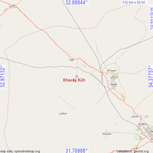
Khavāş Kūh GPS coordinates[2]
32° 18' 21.996" North, 53° 40' 27.984" East
| Map corner | latitude | longitude |
|---|---|---|
| Upper-left | 32.89844°, | 52.97132° |
| Center: | 32.30611°, | 53.67444° |
| Lower-right: | 31.70988°, | 54.37757° |
| Map W x H: | 132.2×132.2 km | = 82.1×82.1mi |
| max Lat: | 39.6482° ⇑67.6% North |
| Khavāş Kūh: | 32.30611° |
| min Lat: | ⇓32.4% South 25.2919° |
| min Long | Khavāş Kūh | max Long |
| 44.38416° | 53.67444° | 61.9965° |
| W 70.3%⇐ | ⇒29.7% E |
Elevation
Elevation of Khavāş Kūh is 1928 m = 6325 ft, and this is 879 m = 2884 ft above average elevation for this country.
| Max E: |
2564 m = 8412 ft | 8.2% |
| Khavāş Kūh | 1928 m 6325 ft | |
| Avg. | 1049 m = 3442 ft | |
Min E: |
-24 m = -79 ft | 91.8% |
See also: Iran elevation on elevation.city.
Geographical zone
Khavāş Kūh is located in North temperate zone (between Tropic of Cancer and the Arctic Circle). Distance of this Northern Tropic circle is 986.2 km =612.8 mi to South.| Distance of | km | miles | from Khavāş Kūh |
|---|---|---|---|
| North Pole | 6415 | 3986.1 | to North |
| Arctic Circle | 3809.1 | 2366.9 | to North |
| Tropic Cancer | 986.2 | 612.8 | to South |
| Equator | 3592.1 | 2232 | to South |


Nearby cities:
15 places around Khavāş Kūh: (largest is in red/bold)
• Abarkūh
136 km =84.5 mi,  195°
195°
• Ardakān
32.2 km =20 mi,  89°
89°
• Ardestān
170.3 km =105.8 mi,  314°
314°
• Bāfq
180.8 km =112.3 mi,  115°
115°
• Dowlatābād
193.4 km =120.2 mi,  286°
286°
• Eqlīd
181.8 km =113 mi,  210°
210°
• Isfahan
191.5 km =119 mi,  281°
281°
• Mahrīz
108.2 km =67.2 mi,  137°
137°
• Meybod
32.8 km =20.4 mi,  100°
100°
• Nā’īn
82.6 km =51.3 mi,  318°
318°
• Shahreẕā
173.3 km =107.7 mi,  259°
259°
• Taft
79.7 km =49.5 mi, 139°
• Taft
79.9 km =49.6 mi, 141°
• Yazd
79.6 km =49.5 mi, 124°
• Ābādeh
160 km =99.4 mi,  217°
217°
Sources, notices
• [Note1] Compared only with cities in Iran existing in our database
• [Src1] Map data: © OpenStreetMap contributors (CC-BY-SA)
• [Src2] Other city data from geonames.org with taken over terms of usage.
• [Src3] Geographical zone / Annual Mean Temperature by Robert A. Rohde @ Wikipedia
