Golpāyegān geodata
Golpāyegān (Isfahan) is a seat of a second-order administrative division; located in Iran in Asia/Tehran (GMT+3.5) time zone. With population of 44,916 people, there are 145 cities with bigger population in this country. Compared to other cities in Iran, 59% of cities are located further ↑North; 59.9% of cities are located further →East and 86.2% of cities have lower elevation than Golpāyegān. Note1


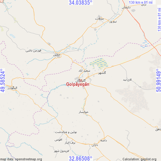
Golpāyegān GPS coordinates[2]
33° 27' 13.32" North, 50° 17' 18.096" East
| Map corner | latitude | longitude |
|---|---|---|
| Upper-left | 34.03835°, | 49.58524° |
| Center: | 33.4537°, | 50.28836° |
| Lower-right: | 32.86508°, | 50.99149° |
| Map W x H: | 130.5×130.5 km | = 81.1×81.1mi |
| max Lat: | 39.6482° ⇑59% North |
| Golpāyegān: | 33.4537° |
| min Lat: | ⇓41% South 25.2919° |
| min Long | Golpāyegān | max Long |
| 44.38416° | 50.28836° | 61.9965° |
| W 40.1%⇐ | ⇒59.9% E |
Elevation
Elevation of Golpāyegān is 1817 m = 5961 ft, and this is 768 m = 2520 ft above average elevation for this country.
| Max E: |
2564 m = 8412 ft | 13.8% |
| Golpāyegān | 1817 m 5961 ft | |
| Avg. | 1049 m = 3442 ft | |
Min E: |
-24 m = -79 ft | 86.2% |
See also: Golpāyegān elevation on elevation.city.
Geographical zone
Golpāyegān is located in North temperate zone (between Tropic of Cancer and the Arctic Circle). Distance of this Northern Tropic circle is 1113.8 km =692.1 mi to South.| Distance of | km | miles | from Golpāyegān |
|---|---|---|---|
| North Pole | 6287.4 | 3906.8 | to North |
| Arctic Circle | 3681.5 | 2287.6 | to North |
| Tropic Cancer | 1113.8 | 692.1 | to South |
| Equator | 3719.7 | 2311.3 | to South |


Nearby cities:
15 places around Golpāyegān: (largest is in red/bold)
• Alīgūdarz
55.6 km =34.5 mi,  264°
264°
• Arāk
89.8 km =55.8 mi,  322°
322°
• Aznā
77.2 km =48 mi,  270°
270°
• Chelgard
110.8 km =68.8 mi,  188°
188°
• Chādegān
82.5 km =51.3 mi,  157°
157°
• Delījān
70 km =43.5 mi,  31°
31°
• Dorūd
113.9 km =70.8 mi, 272°
• Dārān
53 km =32.9 mi,  167°
167°
• Fareydūnshahr
59.1 km =36.7 mi,  195°
195°
• Khomeyn
28.2 km =17.5 mi, 316°
• Khvānsār
26 km =16.2 mi, 174°
• Maḩallāt
53.1 km =33 mi,  16°
16°
• Shāzand
97.4 km =60.5 mi,  303°
303°
• Tīrān
116.1 km =72.1 mi,  136°
136°
• Āshtīān
121.7 km =75.6 mi,  347°
347°
Sources, notices
• [Note1] Compared only with cities in Iran existing in our database
• [Src1] Map data: © OpenStreetMap contributors (CC-BY-SA)
• [Src2] Other city data from geonames.org with taken over terms of usage.
• [Src3] Geographical zone / Annual Mean Temperature by Robert A. Rohde @ Wikipedia
