Chelgard geodata
Chelgard (Chaharmahal and Bakhtiari) is a seat of a second-order administrative division; located in Iran in Asia/Tehran (GMT+3.5) time zone. In our database, there are 232 cities with bigger population. Compared to other cities in Iran, 65.5% of cities are located further ↑North; 61% of cities are located further →East and 99.1% of cities have lower elevation than Chelgard. Note1


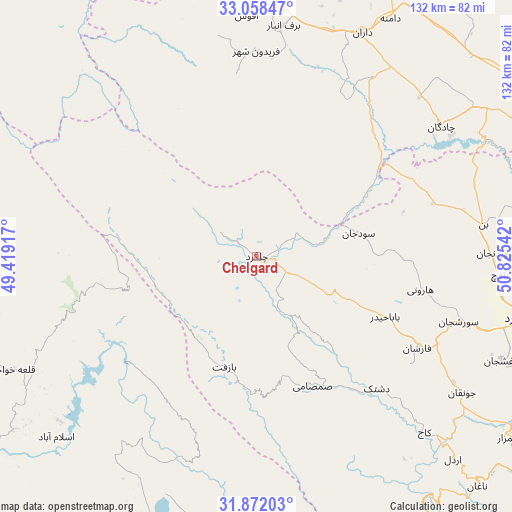
Chelgard GPS coordinates[2]
32° 28' 1.92" North, 50° 7' 20.244" East
| Map corner | latitude | longitude |
|---|---|---|
| Upper-left | 33.05847°, | 49.41917° |
| Center: | 32.4672°, | 50.12229° |
| Lower-right: | 31.87203°, | 50.82542° |
| Map W x H: | 131.9×131.9 km | = 82×82mi |
| max Lat: | 39.6482° ⇑65.5% North |
| Chelgard: | 32.4672° |
| min Lat: | ⇓34.5% South 25.2919° |
| min Long | Chelgard | max Long |
| 44.38416° | 50.12229° | 61.9965° |
| W 39%⇐ | ⇒61% E |
Elevation
Elevation of Chelgard is 2331 m = 7648 ft, and this is 1282 m = 4206 ft above average elevation for this country.
| Max E: |
2564 m = 8412 ft | 0.90000000000001% |
| Chelgard | 2331 m 7648 ft | |
| Avg. | 1049 m = 3442 ft | |
Min E: |
-24 m = -79 ft | 99.1% |
See also: Iran elevation on elevation.city.
Geographical zone
Chelgard is located in North temperate zone (between Tropic of Cancer and the Arctic Circle). Distance of this Northern Tropic circle is 1004.1 km =623.9 mi to South.| Distance of | km | miles | from Chelgard |
|---|---|---|---|
| North Pole | 6397 | 3974.9 | to North |
| Arctic Circle | 3791.2 | 2355.7 | to North |
| Tropic Cancer | 1004.1 | 623.9 | to South |
| Equator | 3610 | 2243.1 | to South |


Nearby cities:
15 places around Chelgard: (largest is in red/bold)
• Ardal
72.7 km =45.2 mi,  135°
135°
• Bāgh-e Malek
107.2 km =66.6 mi,  192°
192°
• Chādegān
58.1 km =36.1 mi,  54°
54°
• Dasht-e Lati
97.8 km =60.8 mi,  261°
261°
• Dārān
64 km =39.8 mi,  25°
25°
• Fareydūnshahr
52.7 km =32.7 mi,  359°
359°
• Farrokh Shahr
83.4 km =51.8 mi,  105°
105°
• Fārsān
47.4 km =29.5 mi,  119°
119°
• Golpāyegān
110.8 km =68.8 mi,  8°
8°
• Khvānsār
85.7 km =53.3 mi, 12°
• Masjed Soleymān
97 km =60.3 mi,  232°
232°
• Qal‘eh-ye Khvājeh
69.9 km =43.4 mi,  245°
245°
• Shahr-e Kord
70.8 km =44 mi,  102°
102°
• Shalamzār
80.3 km =49.9 mi,  125°
125°
• Tīrān
100.1 km =62.2 mi,  74°
74°
Sources, notices
• [Note1] Compared only with cities in Iran existing in our database
• [Src1] Map data: © OpenStreetMap contributors (CC-BY-SA)
• [Src2] Other city data from geonames.org with taken over terms of usage.
• [Src3] Geographical zone / Annual Mean Temperature by Robert A. Rohde @ Wikipedia
