Fareydūnshahr geodata
Fareydūnshahr (Isfahan) is a seat of a second-order administrative division; located in Iran in Asia/Tehran (GMT+3.5) time zone. With population of 11,562 people, there are 206 cities with bigger population in this country. Compared to other cities in Iran, 61.5% of cities are located further ↑North; 61.2% of cities are located further →East and 99.8% of cities have lower elevation than Fareydūnshahr. Note1


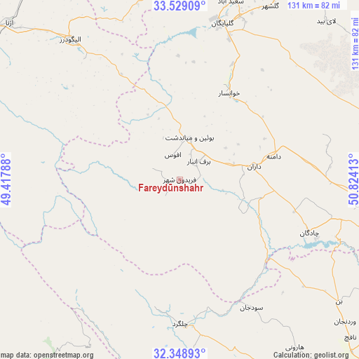
Fareydūnshahr GPS coordinates[2]
32° 56' 27.528" North, 50° 7' 15.6" East
| Map corner | latitude | longitude |
|---|---|---|
| Upper-left | 33.52909°, | 49.41788° |
| Center: | 32.94098°, | 50.121° |
| Lower-right: | 32.34893°, | 50.82413° |
| Map W x H: | 131.2×131.2 km | = 81.5×81.5mi |
| max Lat: | 39.6482° ⇑61.5% North |
| Fareydūnshahr: | 32.94098° |
| min Lat: | ⇓38.5% South 25.2919° |
| min Long | Fareydūnshahr | max Long |
| 44.38416° | 50.121° | 61.9965° |
| W 38.8%⇐ | ⇒61.2% E |
Elevation
Elevation of Fareydūnshahr is 2533 m = 8310 ft, and this is 1484 m = 4869 ft above average elevation for this country.
| Max E: |
2564 m = 8412 ft | 0.2% |
| Fareydūnshahr | 2533 m 8310 ft | |
| Avg. | 1049 m = 3442 ft | |
Min E: |
-24 m = -79 ft | 99.8% |
See also: Iran elevation on elevation.city.
Geographical zone
Fareydūnshahr is located in North temperate zone (between Tropic of Cancer and the Arctic Circle). Distance of this Northern Tropic circle is 1056.8 km =656.7 mi to South.| Distance of | km | miles | from Fareydūnshahr |
|---|---|---|---|
| North Pole | 6344.4 | 3942.2 | to North |
| Arctic Circle | 3738.5 | 2323 | to North |
| Tropic Cancer | 1056.8 | 656.7 | to South |
| Equator | 3662.7 | 2275.9 | to South |


Nearby cities:
15 places around Fareydūnshahr: (largest is in red/bold)
• Alīgūdarz
65.2 km =40.5 mi,  322°
322°
• Aznā
84.3 km =52.4 mi,  312°
312°
• Chelgard
52.7 km =32.7 mi,  179°
179°
• Chādegān
51.2 km =31.8 mi,  112°
112°
• Dorūd
116 km =72.1 mi,  301°
301°
• Dārān
27.7 km =17.2 mi,  78°
78°
• Farrokh Shahr
109.6 km =68.1 mi,  132°
132°
• Fārsān
86.5 km =53.7 mi,  151°
151°
• Golpāyegān
59.1 km =36.7 mi,  15°
15°
• Khomeyn
77.7 km =48.3 mi,  357°
357°
• Khvānsār
36 km =22.4 mi,  30°
30°
• Maḩallāt
112.2 km =69.7 mi, 15°
• Qal‘eh-ye Khvājeh
103.4 km =64.2 mi,  217°
217°
• Shahr-e Kord
97.1 km =60.3 mi, 134°
• Tīrān
100.1 km =62.2 mi, 105°
Sources, notices
• [Note1] Compared only with cities in Iran existing in our database
• [Src1] Map data: © OpenStreetMap contributors (CC-BY-SA)
• [Src2] Other city data from geonames.org with taken over terms of usage.
• [Src3] Geographical zone / Annual Mean Temperature by Robert A. Rohde @ Wikipedia
