Ābyek geodata
Ābyek (Markazi) is a populated place; located in Iran in Asia/Tehran (GMT+3.5) time zone. With population of 55,128 people, there are 115 cities with bigger population in this country. Compared to other cities in Iran, 68.9% of cities are located further ↓South; 57.4% of cities are located further →East and 67.8% of cities have lower elevation than Ābyek. Note1


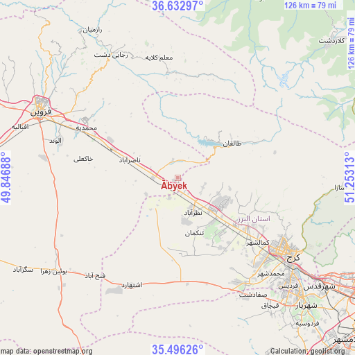
Ābyek GPS coordinates[2]
36° 4' 0.012" North, 50° 33' 0" East
| Map corner | latitude | longitude |
|---|---|---|
| Upper-left | 36.63297°, | 49.84688° |
| Center: | 36.06667°, | 50.55° |
| Lower-right: | 35.49626°, | 51.25313° |
| Map W x H: | 126.4×126.4 km | = 78.5×78.5mi |
| max Lat: | 39.6482° ⇑31.1% North |
| Ābyek: | 36.06667° |
| min Lat: | ⇓68.9% South 25.2919° |
| min Long | Ābyek | max Long |
| 44.38416° | 50.55° | 61.9965° |
| W 42.6%⇐ | ⇒57.4% E |
Elevation
Elevation of Ābyek is 1454 m = 4770 ft, and this is 405 m = 1329 ft above average elevation for this country.
| Max E: |
2564 m = 8412 ft | 32.2% |
| Ābyek | 1454 m 4770 ft | |
| Avg. | 1049 m = 3442 ft | |
Min E: |
-24 m = -79 ft | 67.8% |
See also: Ābyek elevation on elevation.city.
Geographical zone
Ābyek is located in North temperate zone (between Tropic of Cancer and the Arctic Circle). Distance of this Northern Tropic circle is 1404.3 km =872.6 mi to South.| Distance of | km | miles | from Ābyek |
|---|---|---|---|
| North Pole | 5996.8 | 3726.2 | to North |
| Arctic Circle | 3390.9 | 2107 | to North |
| Tropic Cancer | 1404.3 | 872.6 | to South |
| Equator | 4010.2 | 2491.8 | to South |


Nearby cities:
15 places around Ābyek: (largest is in red/bold)
• Alvand
45.7 km =28.4 mi,  287°
287°
• Bū’īn Zahrā
55.5 km =34.5 mi,  233°
233°
• Eshtehārd
41.4 km =25.7 mi,  203°
203°
• Hashtgerd
16.5 km =10.3 mi,  134°
134°
• Karaj
47.5 km =29.5 mi,  123°
123°
• Malārd
58.9 km =36.6 mi,  139°
139°
• Naz̧arābād
13.5 km =8.4 mi,  158°
158°
• Qazvin
53.9 km =33.5 mi, 294°
• Robāţ Karīm
80.6 km =50.1 mi, 143°
• Shahr-e Qods
63.3 km =39.3 mi, 127°
• Shahrak
23 km =14.3 mi,  58°
58°
• Shahre Jadide Andisheh
60.3 km =37.5 mi, 135°
• Shahrīār
64.4 km =40 mi, 134°
• Tākestān
76.8 km =47.7 mi,  270°
270°
• Ābyek
3.4 km =2.1 mi,  209°
209°
Sources, notices
• [Note1] Compared only with cities in Iran existing in our database
• [Src1] Map data: © OpenStreetMap contributors (CC-BY-SA)
• [Src2] Other city data from geonames.org with taken over terms of usage.
• [Src3] Geographical zone / Annual Mean Temperature by Robert A. Rohde @ Wikipedia
