Ābyek geodata
Ābyek (Qazvīn) is a seat of a second-order administrative division; located in Iran in Asia/Tehran (GMT+3.5) time zone. In our database, there are 232 cities with bigger population. Compared to other cities in Iran, 68.7% of cities are located further ↓South; 57.6% of cities are located further →East and 54.9% of cities have lower elevation than Ābyek. Note1


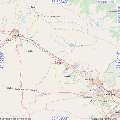
Ābyek GPS coordinates[2]
36° 2' 23.748" North, 50° 31' 51.636" East
| Map corner | latitude | longitude |
|---|---|---|
| Upper-left | 36.60643°, | 49.82789° |
| Center: | 36.03993°, | 50.53101° |
| Lower-right: | 35.46933°, | 51.23414° |
| Map W x H: | 126.4×126.4 km | = 78.5×78.5mi |
| max Lat: | 39.6482° ⇑31.3% North |
| Ābyek: | 36.03993° |
| min Lat: | ⇓68.7% South 25.2919° |
| min Long | Ābyek | max Long |
| 44.38416° | 50.53101° | 61.9965° |
| W 42.4%⇐ | ⇒57.6% E |
Elevation
Elevation of Ābyek is 1258 m = 4127 ft, and this is 209 m = 686 ft above average elevation for this country.
| Max E: |
2564 m = 8412 ft | 45.1% |
| Ābyek | 1258 m 4127 ft | |
| Avg. | 1049 m = 3442 ft | |
Min E: |
-24 m = -79 ft | 54.9% |
See also: Iran elevation on elevation.city.
Geographical zone
Ābyek is located in North temperate zone (between Tropic of Cancer and the Arctic Circle). Distance of this Northern Tropic circle is 1401.3 km =870.7 mi to South.| Distance of | km | miles | from Ābyek |
|---|---|---|---|
| North Pole | 5999.8 | 3728.1 | to North |
| Arctic Circle | 3393.9 | 2108.9 | to North |
| Tropic Cancer | 1401.3 | 870.7 | to South |
| Equator | 4007.3 | 2490 | to South |


Nearby cities:
15 places around Ābyek: (largest is in red/bold)
• Alvand
45.1 km =28 mi,  291°
291°
• Bū’īn Zahrā
52.3 km =32.5 mi,  234°
234°
• Eshtehārd
38 km =23.6 mi,  203°
203°
• Hashtgerd
16 km =9.9 mi,  122°
122°
• Karaj
47.4 km =29.5 mi, 119°
• Malārd
57.8 km =35.9 mi,  135°
135°
• Naz̧arābād
11.7 km =7.3 mi, 144°
• Qazvin
53.7 km =33.4 mi,  298°
298°
• Robāţ Karīm
79.3 km =49.3 mi, 141°
• Shahr-e Qods
63 km =39.1 mi, 124°
• Shahrak
26.1 km =16.2 mi,  55°
55°
• Shahre Jadide Andisheh
59.5 km =37 mi,  132°
132°
• Shahrīār
63.6 km =39.5 mi, 131°
• Tākestān
75.2 km =46.7 mi,  272°
272°
• Ābyek
3.4 km =2.1 mi,  29°
29°
Sources, notices
• [Note1] Compared only with cities in Iran existing in our database
• [Src1] Map data: © OpenStreetMap contributors (CC-BY-SA)
• [Src2] Other city data from geonames.org with taken over terms of usage.
• [Src3] Geographical zone / Annual Mean Temperature by Robert A. Rohde @ Wikipedia
