Tākestān geodata
Tākestān (Qazvīn) is a seat of a second-order administrative division; located in Iran in Asia/Tehran (GMT+3.5) time zone. With population of 71,499 people, there are 92 cities with bigger population in this country. Compared to other cities in Iran, 69.2% of cities are located further ↓South; 64.9% of cities are located further →East and 55.3% of cities have lower elevation than Tākestān. Note1


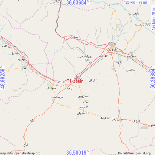
Tākestān GPS coordinates[2]
36° 4' 14.052" North, 49° 41' 44.556" East
| Map corner | latitude | longitude |
|---|---|---|
| Upper-left | 36.63684°, | 48.99259° |
| Center: | 36.07057°, | 49.69571° |
| Lower-right: | 35.50019°, | 50.39884° |
| Map W x H: | 126.4×126.4 km | = 78.5×78.5mi |
| max Lat: | 39.6482° ⇑30.8% North |
| Tākestān: | 36.07057° |
| min Lat: | ⇓69.2% South 25.2919° |
| min Long | Tākestān | max Long |
| 44.38416° | 49.69571° | 61.9965° |
| W 35.1%⇐ | ⇒64.9% E |
Elevation
Elevation of Tākestān is 1265 m = 4150 ft, and this is 216 m = 709 ft above average elevation for this country.
| Max E: |
2564 m = 8412 ft | 44.7% |
| Tākestān | 1265 m 4150 ft | |
| Avg. | 1049 m = 3442 ft | |
Min E: |
-24 m = -79 ft | 55.3% |
See also: Tākestān elevation on elevation.city.
Geographical zone
Tākestān is located in North temperate zone (between Tropic of Cancer and the Arctic Circle). Distance of this Northern Tropic circle is 1404.8 km =872.9 mi to South.| Distance of | km | miles | from Tākestān |
|---|---|---|---|
| North Pole | 5996.4 | 3726 | to North |
| Arctic Circle | 3390.5 | 2106.8 | to North |
| Tropic Cancer | 1404.8 | 872.9 | to South |
| Equator | 4010.7 | 2492.1 | to South |


Nearby cities:
15 places around Tākestān: (largest is in red/bold)
• Abhar
43.7 km =27.2 mi,  281°
281°
• Alvand
35.6 km =22.1 mi,  68°
68°
• Alvand
54.8 km =34.1 mi,  300°
300°
• Bū’īn Zahrā
46.9 km =29.1 mi,  136°
136°
• Eshtehārd
71.5 km =44.4 mi,  122°
122°
• Hashtgerd
89.3 km =55.5 mi,  97°
97°
• Khorramdarreh
47.5 km =29.5 mi,  288°
288°
• Naz̧arābād
82.9 km =51.5 mi, 98°
• Pādegān-e Manjīl
78.7 km =48.9 mi,  341°
341°
• Pā’īn-e Bāzār-e Rūdbār
86.9 km =54 mi, 343°
• Qazvin
35.4 km =22 mi,  51°
51°
• Razan
96.8 km =60.1 mi,  218°
218°
• Shahrak
97.1 km =60.3 mi,  83°
83°
• Ābyek
75.2 km =46.7 mi,  92°
92°
• Ābyek
76.8 km =47.7 mi, 90°
Sources, notices
• [Note1] Compared only with cities in Iran existing in our database
• [Src1] Map data: © OpenStreetMap contributors (CC-BY-SA)
• [Src2] Other city data from geonames.org with taken over terms of usage.
• [Src3] Geographical zone / Annual Mean Temperature by Robert A. Rohde @ Wikipedia
