Gomīshān geodata
Gomīshān (Golestan) is a seat of a second-order administrative division; located in Iran in Asia/Tehran (GMT+3.5) time zone. In our database, there are 232 cities with bigger population. Compared to other cities in Iran, 84.1% of cities are located further ↓South; 72.1% of cities are located further ←West and 99.5% of cities have higher elevation than Gomīshān. Note1


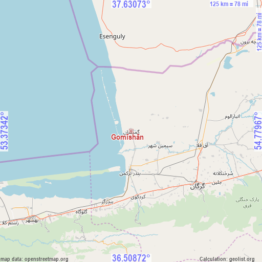
Gomīshān GPS coordinates[2]
37° 4' 18.48" North, 54° 4' 35.544" East
| Map corner | latitude | longitude |
|---|---|---|
| Upper-left | 37.63073°, | 53.37342° |
| Center: | 37.0718°, | 54.07654° |
| Lower-right: | 36.50872°, | 54.77967° |
| Map W x H: | 124.8×124.8 km | = 77.5×77.5mi |
| max Lat: | 39.6482° ⇑15.9% North |
| Gomīshān: | 37.0718° |
| min Lat: | ⇓84.1% South 25.2919° |
| min Long | Gomīshān | max Long |
| 44.38416° | 54.07654° | 61.9965° |
| W 72.1%⇐ | ⇒27.9% E |
Elevation
Elevation of Gomīshān is -23 m = -75 ft, and this is 1072 m = 3517 ft below average elevation for this country.
| Max E: |
2564 m = 8412 ft | 99.5% |
| Avg. | 1049 m = 3442 ft | |
| Gomīshān | -23 m = -75 ft | |
Min E: |
-24 m = -79 ft | 0.5% |
See also: Iran elevation on elevation.city.
Geographical zone
Gomīshān is located in North temperate zone (between Tropic of Cancer and the Arctic Circle). Distance of this Northern Tropic circle is 1516.1 km =942.1 mi to South.| Distance of | km | miles | from Gomīshān |
|---|---|---|---|
| North Pole | 5885.1 | 3656.8 | to North |
| Arctic Circle | 3279.2 | 2037.6 | to North |
| Tropic Cancer | 1516.1 | 942.1 | to South |
| Equator | 4122 | 2561.3 | to South |


Nearby cities:
15 places around Gomīshān: (largest is in red/bold)
• Aliabad-e Katul
72.5 km =45 mi,  104°
104°
• Bandar-e Gaz
35 km =21.7 mi,  199°
199°
• Bandar-e Torkaman
19 km =11.8 mi,  181°
181°
• Behshahr
62.9 km =39.1 mi,  227°
227°
• Galūgāh
45.1 km =28 mi,  211°
211°
• Gonbad-e Kāvūs
98.7 km =61.3 mi,  78°
78°
• Gorgān
41.4 km =25.7 mi,  127°
127°
• Kord Kūy
31.2 km =19.4 mi,  174°
174°
• Nekā
83.5 km =51.9 mi,  235°
235°
• Qarnābād
53.6 km =33.3 mi,  121°
121°
• Rāmīān
94.7 km =58.8 mi,  93°
93°
• Sūrak
93.8 km =58.3 mi, 235°
• Āq Qalā
34.2 km =21.3 mi, 100°
• Āq Qāyeh
98.5 km =61.2 mi, 76°
• Āzādshahr
97.2 km =60.4 mi, 89°
Sources, notices
• [Note1] Compared only with cities in Iran existing in our database
• [Src1] Map data: © OpenStreetMap contributors (CC-BY-SA)
• [Src2] Other city data from geonames.org with taken over terms of usage.
• [Src3] Geographical zone / Annual Mean Temperature by Robert A. Rohde @ Wikipedia
