Āq Qāyeh geodata
Āq Qāyeh (Golestan) is a populated place; located in Iran in Asia/Tehran (GMT+3.5) time zone. With population of 5,114 people, there are 212 cities with bigger population in this country. Compared to other cities in Iran, 88.4% of cities are located further ↓South; 77.3% of cities are located further ←West and 86.4% of cities have higher elevation than Āq Qāyeh. Note1


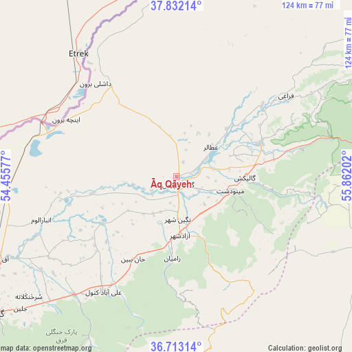
Āq Qāyeh GPS coordinates[2]
37° 16' 28.992" North, 55° 9' 32.004" East
| Map corner | latitude | longitude |
|---|---|---|
| Upper-left | 37.83214°, | 54.45577° |
| Center: | 37.27472°, | 55.15889° |
| Lower-right: | 36.71314°, | 55.86202° |
| Map W x H: | 124.4×124.4 km | = 77.3×77.3mi |
| max Lat: | 39.6482° ⇑11.6% North |
| Āq Qāyeh: | 37.27472° |
| min Lat: | ⇓88.4% South 25.2919° |
| min Long | Āq Qāyeh | max Long |
| 44.38416° | 55.15889° | 61.9965° |
| W 77.3%⇐ | ⇒22.7% E |
Elevation
Elevation of Āq Qāyeh is 37 m = 121 ft, and this is 1012 m = 3320 ft below average elevation for this country.
| Max E: |
2564 m = 8412 ft | 86.4% |
| Avg. | 1049 m = 3442 ft | |
| Āq Qāyeh | 37 m = 121 ft | |
Min E: |
-24 m = -79 ft | 13.6% |
See also: Iran elevation on elevation.city.
Geographical zone
Āq Qāyeh is located in North temperate zone (between Tropic of Cancer and the Arctic Circle). Distance of this Northern Tropic circle is 1538.6 km =956 mi to South.| Distance of | km | miles | from Āq Qāyeh |
|---|---|---|---|
| North Pole | 5862.5 | 3642.8 | to North |
| Arctic Circle | 3256.6 | 2023.6 | to North |
| Tropic Cancer | 1538.6 | 956 | to South |
| Equator | 4144.6 | 2575.3 | to South |


Nearby cities:
15 places around Āq Qāyeh: (largest is in red/bold)
• Aliabad-e Katul
48.1 km =29.9 mi,  212°
212°
• Bandar-e Torkaman
105 km =65.2 mi,  246°
246°
• Garmeh
105.2 km =65.4 mi,  107°
107°
• Gomīshān
98.5 km =61.2 mi,  256°
256°
• Gonbad-e Kāvūs
2.8 km =1.7 mi,  164°
164°
• Gorgān
79.6 km =49.5 mi,  232°
232°
• Gālīkesh
24.3 km =15.1 mi,  90°
90°
• Kalāleh
31.7 km =19.7 mi,  68°
68°
• Marāveh Tappeh
99.1 km =61.6 mi,  45°
45°
• Mīnūdasht
19.5 km =12.1 mi,  104°
104°
• Qarnābād
71.2 km =44.2 mi,  224°
224°
• Rāmīān
28.8 km =17.9 mi,  183°
183°
• Shahrud
96.6 km =60 mi,  189°
189°
• Āq Qalā
68.8 km =42.8 mi, 245°
• Āzādshahr
21 km =13 mi, 176°
Sources, notices
• [Note1] Compared only with cities in Iran existing in our database
• [Src1] Map data: © OpenStreetMap contributors (CC-BY-SA)
• [Src2] Other city data from geonames.org with taken over terms of usage.
• [Src3] Geographical zone / Annual Mean Temperature by Robert A. Rohde @ Wikipedia
