Skagaströnd geodata
Skagaströnd (Northwest) is a populated place; located in Iceland in Atlantic/Reykjavik (GMT+0) time zone. With population of 501 people, there are 45 cities with bigger population in this country. Compared to other cities in Iceland, 87% of cities are located further ↓South; 60.9% of cities are located further ←West and 54.3% of cities have higher elevation than Skagaströnd. Note1


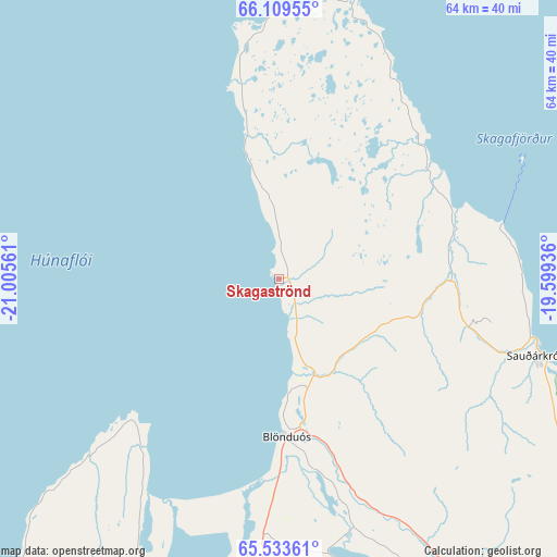
Skagaströnd GPS coordinates[2]
65° 49' 23.484" North, 20° 18' 8.928" West
| Map corner | latitude | longitude |
|---|---|---|
| Upper-left | 66.10955°, | -21.00561° |
| Center: | 65.82319°, | -20.30248° |
| Lower-right: | 65.53361°, | -19.59936° |
| Map W x H: | 64×64 km | = 39.8×39.8mi |
| max Lat: | 66.15917° ⇑13% North |
| Skagaströnd: | 65.82319° |
| min Lat: | ⇓87% South 63.44273° |
| min Long | Skagaströnd | max Long |
| -23.99596° | -20.30248° | -13.68368° |
| W 60.9%⇐ | ⇒39.1% E |
Elevation
Elevation of Skagaströnd is 15 m = 49 ft, and this is 6.3 m = 21 ft below average elevation for this country.
| Max E: |
105 m = 344 ft | 54.3% |
| Avg. | 21.3 m = 70 ft | |
| Skagaströnd | 15 m = 49 ft | |
Min E: |
1 m = 3 ft | 45.7% |
See also: Iceland elevation on elevation.city.
Geographical zone
Skagaströnd is located in North temperate zone (between Tropic of Cancer and the Arctic Circle). Distance of this North polar circle is 82.3 km =51.1 mi to North.| Distance of | km | miles | from Skagaströnd |
|---|---|---|---|
| North Pole | 2688.2 | 1670.4 | to North |
| Arctic Circle | 82.3 | 51.1 | to North |
| Tropic Cancer | 4712.9 | 2928.5 | to South |
| Equator | 7318.9 | 4547.8 | to South |


Nearby cities:
15 places around Skagaströnd: (largest is in red/bold)
• Akureyri
102.3 km =63.6 mi,  98°
98°
• Blönduós
18.2 km =11.3 mi,  176°
176°
• Bolungarvík
138.4 km =86 mi,  285°
285°
• Borgarnes
161.6 km =100.4 mi,  207°
207°
• Dalvík
82.2 km =51.1 mi,  78°
78°
• Grundarfjörður
169.7 km =105.4 mi,  233°
233°
• Hvammstangi
55.8 km =34.7 mi, 211°
• Húsavík
136.6 km =84.9 mi, 79°
• Laugar
134.1 km =83.3 mi,  94°
94°
• Patreksfjörður
170.8 km =106.1 mi,  261°
261°
• Sauðárkrókur
31.4 km =19.5 mi,  105°
105°
• Siglufjörður
72.9 km =45.3 mi,  59°
59°
• Stykkishólmur
139.6 km =86.7 mi, 233°
• Ísafjörður
131.4 km =81.6 mi,  282°
282°
• Ólafsfjörður
79.9 km =49.6 mi,  70°
70°
Sources, notices
• [Note1] Compared only with cities in Iceland existing in our database
• [Src1] Map data: © OpenStreetMap contributors (CC-BY-SA)
• [Src2] Other city data from geonames.org with taken over terms of usage.
• [Src3] Geographical zone / Annual Mean Temperature by Robert A. Rohde @ Wikipedia
