Muravera geodata
Muravera (Sardinia) is a seat of a third-order administrative division; located in Italy in Europe/Rome (GMT+2) time zone. With population of 4,424 people, there are 2178 cities with bigger population in this country. Compared to other cities in Italy, 90.7% of cities are located further ↑North; 72.3% of cities are located further →East and 91.5% of cities have higher elevation than Muravera. Note1


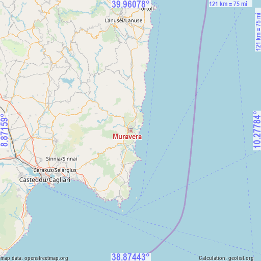
Muravera GPS coordinates[2]
39° 25' 10.992" North, 9° 34' 28.956" East
| Map corner | latitude | longitude |
|---|---|---|
| Upper-left | 39.96078°, | 8.87159° |
| Center: | 39.41972°, | 9.57471° |
| Lower-right: | 38.87443°, | 10.27784° |
| Map W x H: | 120.8×120.8 km | = 75.1×75.1mi |
| max Lat: | 47.04031° ⇑90.7% North |
| Muravera: | 39.41972° |
| min Lat: | ⇓9.3% South 35.50142° |
| min Long | Muravera | max Long |
| 6.69888° | 9.57471° | 18.48682° |
| W 27.7%⇐ | ⇒72.3% E |
Elevation
Elevation of Muravera is 15 m = 49 ft, and this is 291.7 m = 957 ft below average elevation for this country.
| Max E: |
2085 m = 6841 ft | 91.5% |
| Avg. | 306.7 m = 1006 ft | |
| Muravera | 15 m = 49 ft | |
Min E: |
-4 m = -13 ft | 8.5% |
See also: Italy elevation on elevation.city.
Geographical zone
Muravera is located in North temperate zone (between Tropic of Cancer and the Arctic Circle). Distance of this Northern Tropic circle is 1777.1 km =1104.2 mi to South.| Distance of | km | miles | from Muravera |
|---|---|---|---|
| North Pole | 5624 | 3494.6 | to North |
| Arctic Circle | 3018.1 | 1875.4 | to North |
| Tropic Cancer | 1777.1 | 1104.2 | to South |
| Equator | 4383.1 | 2723.5 | to South |


Nearby cities:
15 places around Muravera: (largest is in red/bold)
• Armungia
20.1 km =12.5 mi,  304°
304°
• Ballao
23.3 km =14.5 mi,  308°
308°
• Burcei
20.3 km =12.6 mi,  245°
245°
• Castiadas
21.3 km =13.2 mi,  197°
197°
• Escalaplano
29.7 km =18.5 mi,  320°
320°
• Goni
30.5 km =19 mi, 305°
• Olia Speciosa
16.3 km =10.1 mi, 195°
• San Nicolo'Gerrei
24.7 km =15.3 mi,  290°
290°
• San Vito
3.8 km =2.4 mi, 309°
• Santa Maria
2.7 km =1.7 mi,  40°
40°
• Silius
26.4 km =16.4 mi, 294°
• Tertenia
30.6 km =19 mi,  0°
0°
• Villaputzu
2.3 km =1.4 mi, 1°
• Villasalto
17.8 km =11.1 mi, 296°
• Villasimius
31 km =19.3 mi,  189°
189°
Sources, notices
• [Note1] Compared only with cities in Italy existing in our database
• [Src1] Map data: © OpenStreetMap contributors (CC-BY-SA)
• [Src2] Other city data from geonames.org with taken over terms of usage.
• [Src3] Geographical zone / Annual Mean Temperature by Robert A. Rohde @ Wikipedia
