Guspini geodata
Guspini (Sardinia) is a seat of a third-order administrative division; located in Italy in Europe/Rome (GMT+2) time zone. With population of 11,704 people, there are 798 cities with bigger population in this country. Compared to other cities in Italy, 90.2% of cities are located further ↑North; 86.3% of cities are located further →East and 63% of cities have higher elevation than Guspini. Note1


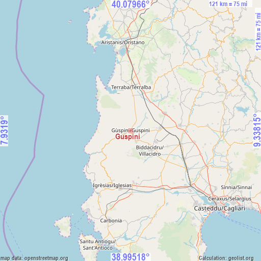
Guspini GPS coordinates[2]
39° 32' 22.344" North, 8° 38' 6.072" East
| Map corner | latitude | longitude |
|---|---|---|
| Upper-left | 40.07966°, | 7.9319° |
| Center: | 39.53954°, | 8.63502° |
| Lower-right: | 38.99518°, | 9.33815° |
| Map W x H: | 120.6×120.6 km | = 74.9×74.9mi |
| max Lat: | 47.04031° ⇑90.2% North |
| Guspini: | 39.53954° |
| min Lat: | ⇓9.8% South 35.50142° |
| min Long | Guspini | max Long |
| 6.69888° | 8.63502° | 18.48682° |
| W 13.7%⇐ | ⇒86.3% E |
Elevation
Elevation of Guspini is 141 m = 463 ft, and this is 165.7 m = 544 ft below average elevation for this country.
| Max E: |
2085 m = 6841 ft | 63% |
| Avg. | 306.7 m = 1006 ft | |
| Guspini | 141 m = 463 ft | |
Min E: |
-4 m = -13 ft | 37% |
See also: Italy elevation on elevation.city.
Geographical zone
Guspini is located in North temperate zone (between Tropic of Cancer and the Arctic Circle). Distance of this Northern Tropic circle is 1790.5 km =1112.6 mi to South.| Distance of | km | miles | from Guspini |
|---|---|---|---|
| North Pole | 5610.7 | 3486.3 | to North |
| Arctic Circle | 3004.8 | 1867.1 | to North |
| Tropic Cancer | 1790.5 | 1112.6 | to South |
| Equator | 4396.4 | 2731.8 | to South |


Nearby cities:
15 places around Guspini: (largest is in red/bold)
• Arbus
3.4 km =2.1 mi,  243°
243°
• Collinas
20.8 km =12.9 mi,  57°
57°
• Fluminimaggiore
16.3 km =10.1 mi,  226°
226°
• Gonnosfanadiga
5.5 km =3.4 mi,  155°
155°
• Masullas
22 km =13.7 mi,  35°
35°
• Mogoro
20.1 km =12.5 mi, 37°
• Pabillonis
9.4 km =5.8 mi,  51°
51°
• San Gavino Monreale
13.4 km =8.3 mi,  84°
84°
• San Nicolò d'Arcidano
16.1 km =10 mi,  2°
2°
• Sardara
18 km =11.2 mi, 62°
• Siris
22.6 km =14 mi,  31°
31°
• Tanca Marchese
22.5 km =14 mi,  353°
353°
• Terralba
20.1 km =12.5 mi, 0°
• Uras
18.5 km =11.5 mi,  17°
17°
• Villacidro
12.9 km =8 mi,  135°
135°
Sources, notices
• [Note1] Compared only with cities in Italy existing in our database
• [Src1] Map data: © OpenStreetMap contributors (CC-BY-SA)
• [Src2] Other city data from geonames.org with taken over terms of usage.
• [Src3] Geographical zone / Annual Mean Temperature by Robert A. Rohde @ Wikipedia
