Arbus geodata
Arbus (Sardinia) is a seat of a third-order administrative division; located in Italy in Europe/Rome (GMT+2) time zone. With population of 5,892 people, there are 1666 cities with bigger population in this country. Compared to other cities in Italy, 90.2% of cities are located further ↑North; 86.7% of cities are located further →East and 59.6% of cities have lower elevation than Arbus. Note1


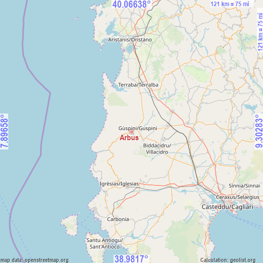
Arbus GPS coordinates[2]
39° 31' 34.176" North, 8° 35' 58.92" East
| Map corner | latitude | longitude |
|---|---|---|
| Upper-left | 40.06638°, | 7.89658° |
| Center: | 39.52616°, | 8.5997° |
| Lower-right: | 38.9817°, | 9.30283° |
| Map W x H: | 120.6×120.6 km | = 74.9×74.9mi |
| max Lat: | 47.04031° ⇑90.2% North |
| Arbus: | 39.52616° |
| min Lat: | ⇓9.8% South 35.50142° |
| min Long | Arbus | max Long |
| 6.69888° | 8.5997° | 18.48682° |
| W 13.3%⇐ | ⇒86.7% E |
Elevation
Elevation of Arbus is 297 m = 974 ft, and this is 9.7 m = 32 ft below average elevation for this country.
| Max E: |
2085 m = 6841 ft | 40.4% |
| Avg. | 306.7 m = 1006 ft | |
| Arbus | 297 m = 974 ft | |
Min E: |
-4 m = -13 ft | 59.6% |
See also: Italy elevation on elevation.city.
Geographical zone
Arbus is located in North temperate zone (between Tropic of Cancer and the Arctic Circle). Distance of this Northern Tropic circle is 1789 km =1111.6 mi to South.| Distance of | km | miles | from Arbus |
|---|---|---|---|
| North Pole | 5612.2 | 3487.3 | to North |
| Arctic Circle | 3006.3 | 1868 | to North |
| Tropic Cancer | 1789 | 1111.6 | to South |
| Equator | 4394.9 | 2730.9 | to South |


Nearby cities:
15 places around Arbus: (largest is in red/bold)
• Buggerru
22.1 km =13.7 mi,  230°
230°
• Collinas
24.2 km =15 mi,  58°
58°
• Domusnovas
22.9 km =14.2 mi,  169°
169°
• Fluminimaggiore
13.1 km =8.1 mi,  222°
222°
• Gonnosfanadiga
6.4 km =4 mi,  123°
123°
• Guspini
3.4 km =2.1 mi, 63°
• Mogoro
23.2 km =14.4 mi,  40°
40°
• Pabillonis
12.8 km =8 mi,  54°
54°
• San Gavino Monreale
16.6 km =10.3 mi,  80°
80°
• San Nicolò d'Arcidano
18 km =11.2 mi,  12°
12°
• Sardara
21.4 km =13.3 mi, 62°
• Tanca Marchese
23.8 km =14.8 mi,  1°
1°
• Terralba
21.8 km =13.5 mi, 7°
• Uras
21 km =13 mi,  24°
24°
• Villacidro
14.3 km =8.9 mi, 122°
Sources, notices
• [Note1] Compared only with cities in Italy existing in our database
• [Src1] Map data: © OpenStreetMap contributors (CC-BY-SA)
• [Src2] Other city data from geonames.org with taken over terms of usage.
• [Src3] Geographical zone / Annual Mean Temperature by Robert A. Rohde @ Wikipedia
