Pierantonio geodata
Pierantonio (Umbria) is a populated place; located in Italy in Europe/Rome (GMT+2) time zone. With population of 897 people, there are 7170 cities with bigger population in this country. Compared to other cities in Italy, 61.4% of cities are located further ↑North; 61.1% of cities are located further ←West and 50.7% of cities have lower elevation than Pierantonio. Note1


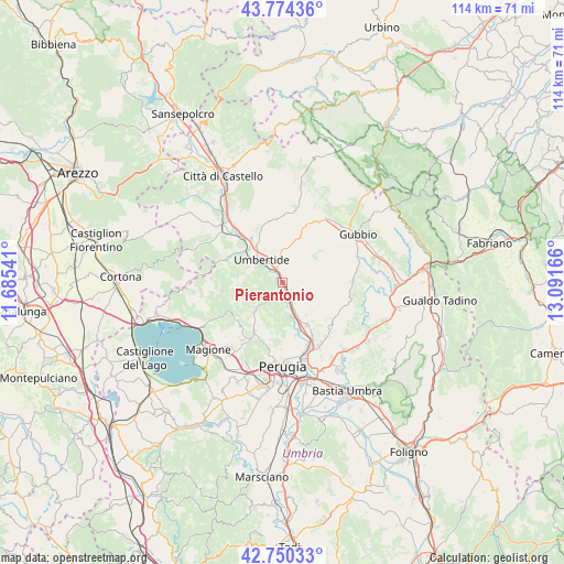
Pierantonio GPS coordinates[2]
43° 15' 52.2" North, 12° 23' 18.708" East
| Map corner | latitude | longitude |
|---|---|---|
| Upper-left | 43.77436°, | 11.68541° |
| Center: | 43.2645°, | 12.38853° |
| Lower-right: | 42.75033°, | 13.09166° |
| Map W x H: | 113.9×113.9 km | = 70.8×70.8mi |
| max Lat: | 47.04031° ⇑61.4% North |
| Pierantonio: | 43.2645° |
| min Lat: | ⇓38.6% South 35.50142° |
| min Long | Pierantonio | max Long |
| 6.69888° | 12.38853° | 18.48682° |
| W 61.1%⇐ | ⇒38.9% E |
Elevation
Elevation of Pierantonio is 239 m = 784 ft, and this is 67.7 m = 222 ft below average elevation for this country.
| Max E: |
2085 m = 6841 ft | 49.3% |
| Avg. | 306.7 m = 1006 ft | |
| Pierantonio | 239 m = 784 ft | |
Min E: |
-4 m = -13 ft | 50.7% |
See also: Italy elevation on elevation.city.
Geographical zone
Pierantonio is located in North temperate zone (between Tropic of Cancer and the Arctic Circle). Distance of this Northern Tropic circle is 2204.6 km =1369.9 mi to South.| Distance of | km | miles | from Pierantonio |
|---|---|---|---|
| North Pole | 5196.5 | 3229 | to North |
| Arctic Circle | 2590.6 | 1609.7 | to North |
| Tropic Cancer | 2204.6 | 1369.9 | to South |
| Equator | 4810.6 | 2989.2 | to South |


Nearby cities:
15 places around Pierantonio: (largest is in red/bold)
• Casa del Diavolo
9.9 km =6.2 mi,  150°
150°
• Colombella
14.6 km =9.1 mi, 148°
• Comparati
12.8 km =8 mi,  203°
203°
• Fratticiola Selvatica
15.6 km =9.7 mi,  122°
122°
• La Cinella
1 km =0.6 mi,  133°
133°
• Mantignana
14.2 km =8.8 mi,  214°
214°
• Montone
11.9 km =7.4 mi,  333°
333°
• Oscano
12.5 km =7.8 mi, 199°
• Osteria di Ramazzano
12 km =7.5 mi, 150°
• Piccione
13.5 km =8.4 mi, 133°
• Ponte Pattoli
10.1 km =6.3 mi,  161°
161°
• Promano
15.1 km =9.4 mi,  319°
319°
• Resina I
7.5 km =4.7 mi, 156°
• Stazione di Parlesca e Solfagnano
5.4 km =3.4 mi, 158°
• Umbertide
6 km =3.7 mi, 316°
Sources, notices
• [Note1] Compared only with cities in Italy existing in our database
• [Src1] Map data: © OpenStreetMap contributors (CC-BY-SA)
• [Src2] Other city data from geonames.org with taken over terms of usage.
• [Src3] Geographical zone / Annual Mean Temperature by Robert A. Rohde @ Wikipedia
