Farini geodata
Farini (Emilia-Romagna) is a seat of a third-order administrative division; located in Italy in Europe/Rome (GMT+2) time zone. With population of 254 people, there are 10875 cities with bigger population in this country. Compared to other cities in Italy, 54.5% of cities are located further ↓South; 72.4% of cities are located further →East and 73.3% of cities have lower elevation than Farini. Note1


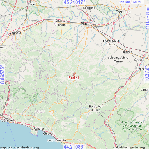
Farini GPS coordinates[2]
44° 42' 45.576" North, 9° 34' 7.932" East
| Map corner | latitude | longitude |
|---|---|---|
| Upper-left | 45.21017°, | 8.86575° |
| Center: | 44.71266°, | 9.56887° |
| Lower-right: | 44.21083°, | 10.272° |
| Map W x H: | 111.1×111.1 km | = 69×69mi |
| max Lat: | 47.04031° ⇑45.5% North |
| Farini: | 44.71266° |
| min Lat: | ⇓54.5% South 35.50142° |
| min Long | Farini | max Long |
| 6.69888° | 9.56887° | 18.48682° |
| W 27.6%⇐ | ⇒72.4% E |
Elevation
Elevation of Farini is 428 m = 1404 ft, and this is 121.3 m = 398 ft above average elevation for this country.
| Max E: |
2085 m = 6841 ft | 26.7% |
| Farini | 428 m 1404 ft | |
| Avg. | 306.7 m = 1006 ft | |
Min E: |
-4 m = -13 ft | 73.3% |
See also: Italy elevation on elevation.city.
Geographical zone
Farini is located in North temperate zone (between Tropic of Cancer and the Arctic Circle). Distance of this Northern Tropic circle is 2365.7 km =1470 mi to South.| Distance of | km | miles | from Farini |
|---|---|---|---|
| North Pole | 5035.5 | 3128.9 | to North |
| Arctic Circle | 2429.6 | 1509.7 | to North |
| Tropic Cancer | 2365.7 | 1470 | to South |
| Equator | 4971.6 | 3089.2 | to South |


Nearby cities:
15 places around Farini: (largest is in red/bold)
• Bardi
15.6 km =9.7 mi,  125°
125°
• Bettola
7.9 km =4.9 mi,  23°
23°
• Bobbio
15.8 km =9.8 mi,  292°
292°
• Bore
17.6 km =10.9 mi,  87°
87°
• Cerignale
17.7 km =11 mi,  257°
257°
• Coli
12.7 km =7.9 mi, 286°
• Ferriere
9.6 km =6 mi,  216°
216°
• Gropparello
18.4 km =11.4 mi,  43°
43°
• Marsaglia
14.6 km =9.1 mi,  269°
269°
• Morfasso
10.6 km =6.6 mi,  83°
83°
• Ottone
21.2 km =13.2 mi,  241°
241°
• Ponte dell'Olio
18.2 km =11.3 mi, 19°
• San Giovanni-San Bernardino
9.5 km =5.9 mi, 19°
• Santo Stefano d'Aveto
20.6 km =12.8 mi,  206°
206°
• Travo
16.9 km =10.5 mi,  353°
353°
Sources, notices
• [Note1] Compared only with cities in Italy existing in our database
• [Src1] Map data: © OpenStreetMap contributors (CC-BY-SA)
• [Src2] Other city data from geonames.org with taken over terms of usage.
• [Src3] Geographical zone / Annual Mean Temperature by Robert A. Rohde @ Wikipedia
