Gagliole geodata
Gagliole (The Marches) is a seat of a third-order administrative division; located in Italy in Europe/Rome (GMT+2) time zone. With population of 130 people, there are 11351 cities with bigger population in this country. Compared to other cities in Italy, 61.6% of cities are located further ↑North; 69% of cities are located further ←West and 77% of cities have lower elevation than Gagliole. Note1


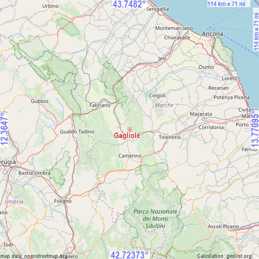
Gagliole GPS coordinates[2]
43° 14' 17.232" North, 13° 4' 4.152" East
| Map corner | latitude | longitude |
|---|---|---|
| Upper-left | 43.7482°, | 12.3647° |
| Center: | 43.23812°, | 13.06782° |
| Lower-right: | 42.72373°, | 13.77095° |
| Map W x H: | 113.9×113.9 km | = 70.8×70.8mi |
| max Lat: | 47.04031° ⇑61.6% North |
| Gagliole: | 43.23812° |
| min Lat: | ⇓38.4% South 35.50142° |
| min Long | Gagliole | max Long |
| 6.69888° | 13.06782° | 18.48682° |
| W 69%⇐ | ⇒31% E |
Elevation
Elevation of Gagliole is 479 m = 1572 ft, and this is 172.3 m = 565 ft above average elevation for this country.
| Max E: |
2085 m = 6841 ft | 23% |
| Gagliole | 479 m 1572 ft | |
| Avg. | 306.7 m = 1006 ft | |
Min E: |
-4 m = -13 ft | 77% |
See also: Italy elevation on elevation.city.
Geographical zone
Gagliole is located in North temperate zone (between Tropic of Cancer and the Arctic Circle). Distance of this Northern Tropic circle is 2201.7 km =1368.1 mi to South.| Distance of | km | miles | from Gagliole |
|---|---|---|---|
| North Pole | 5199.4 | 3230.8 | to North |
| Arctic Circle | 2593.5 | 1611.5 | to North |
| Tropic Cancer | 2201.7 | 1368.1 | to South |
| Equator | 4807.6 | 2987.3 | to South |


Nearby cities:
15 places around Gagliole: (largest is in red/bold)
• Belforte del Chienti
16.4 km =10.2 mi,  120°
120°
• Caldarola
16.5 km =10.3 mi,  129°
129°
• Camerino
11.1 km =6.9 mi,  179°
179°
• Castelraimondo
3.5 km =2.2 mi,  197°
197°
• Cerreto d'Esi
10.9 km =6.8 mi,  323°
323°
• Cesolo
10.5 km =6.5 mi,  76°
76°
• Esanatoglia
9.7 km =6 mi,  279°
279°
• Massa
12.4 km =7.7 mi,  243°
243°
• Matelica
5.4 km =3.4 mi,  294°
294°
• Muccia
17.4 km =10.8 mi,  186°
186°
• Pioraco
9.8 km =6.1 mi,  229°
229°
• Poggio San Vicino
15.2 km =9.4 mi,  3°
3°
• San Severino Marche
9.1 km =5.7 mi,  95°
95°
• Sefro
14 km =8.7 mi,  223°
223°
• Serrapetrona
12 km =7.5 mi, 124°
Sources, notices
• [Note1] Compared only with cities in Italy existing in our database
• [Src1] Map data: © OpenStreetMap contributors (CC-BY-SA)
• [Src2] Other city data from geonames.org with taken over terms of usage.
• [Src3] Geographical zone / Annual Mean Temperature by Robert A. Rohde @ Wikipedia
