San Severino Marche geodata
San Severino Marche (The Marches) is a seat of a third-order administrative division; located in Italy in Europe/Rome (GMT+2) time zone. With population of 8,655 people, there are 1102 cities with bigger population in this country. Compared to other cities in Italy, 61.7% of cities are located further ↑North; 70.2% of cities are located further ←West and 50% of cities have lower elevation than San Severino Marche. Note1
Administrative division(s):
- Level 1: The Marches
- Level 2: Provincia di Macerata
- Level 3: San Severino Marche


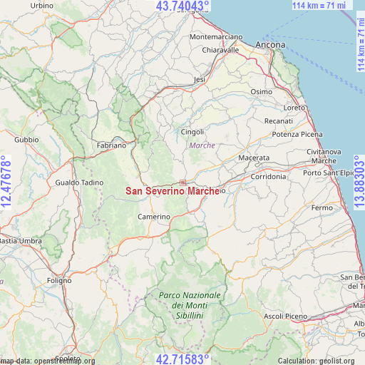
San Severino Marche GPS coordinates[2]
43° 13' 49.008" North, 13° 10' 47.64" East
| Map corner | latitude | longitude |
|---|---|---|
| Upper-left | 43.74043°, | 12.47678° |
| Center: | 43.23028°, | 13.1799° |
| Lower-right: | 42.71583°, | 13.88303° |
| Map W x H: | 113.9×113.9 km | = 70.8×70.8mi |
| max Lat: | 47.04031° ⇑61.7% North |
| San Severino Marche: | 43.23028° |
| min Lat: | ⇓38.3% South 35.50142° |
| min Long | San Severino Ma | max Long |
| 6.69888° | 13.1799° | 18.48682° |
| W 70.2%⇐ | ⇒29.8% E |
Elevation
Elevation of San Severino Marche is 235 m = 771 ft, and this is 71.7 m = 235 ft below average elevation for this country.
| Max E: |
2085 m = 6841 ft | 50% |
| Avg. | 306.7 m = 1006 ft | |
| San Severino Marche | 235 m = 771 ft | |
Min E: |
-4 m = -13 ft | 50% |
See also: Italy elevation on elevation.city.
Geographical zone
San Severino Marche is located in North temperate zone (between Tropic of Cancer and the Arctic Circle). Distance of this Northern Tropic circle is 2200.8 km =1367.5 mi to South.| Distance of | km | miles | from San Severino Marche |
|---|---|---|---|
| North Pole | 5200.3 | 3231.3 | to North |
| Arctic Circle | 2594.4 | 1612.1 | to North |
| Tropic Cancer | 2200.8 | 1367.5 | to South |
| Equator | 4806.8 | 2986.8 | to South |


Nearby cities:
15 places around San Severino Marche: (largest is in red/bold)
• Belforte del Chienti
9 km =5.6 mi,  145°
145°
• Caldarola
10.4 km =6.5 mi,  159°
159°
• Camerino
13.6 km =8.5 mi,  221°
221°
• Camporotondo di Fiastrone
13 km =8.1 mi, 147°
• Castelraimondo
10.4 km =6.5 mi,  256°
256°
• Cesolo
3.6 km =2.2 mi,  17°
17°
• Cessapalombo
15 km =9.3 mi, 155°
• Gagliole
9.1 km =5.7 mi,  275°
275°
• Grottaccia
14.9 km =9.3 mi,  30°
30°
• Matelica
14.3 km =8.9 mi, 282°
• Passo di Treia
13.8 km =8.6 mi,  63°
63°
• Pollenza
14.2 km =8.8 mi,  73°
73°
• Serrapetrona
6 km =3.7 mi,  172°
172°
• Tolentino
8.9 km =5.5 mi,  105°
105°
• Treia
13.7 km =8.5 mi,  50°
50°
Sources, notices
• [Note1] Compared only with cities in Italy existing in our database
• [Src1] Map data: © OpenStreetMap contributors (CC-BY-SA)
• [Src2] Other city data from geonames.org with taken over terms of usage.
• [Src3] Geographical zone / Annual Mean Temperature by Robert A. Rohde @ Wikipedia
