Rehab geodata
Rehab (Mafraq) is a historical populated place; located in Jordan in Asia/Amman (GMT+3) time zone. With population of 10,000 people, there are 36 cities with bigger population in this country. Compared to other cities in Jordan, 64.5% of cities are located further ↓South; 85.5% of cities are located further ←West and 76.8% of cities have lower elevation than Rehab. Note1


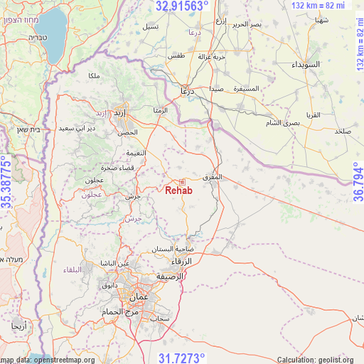
Rehab GPS coordinates[2]
32° 19' 24.276" North, 36° 5' 27.132" East
| Map corner | latitude | longitude |
|---|---|---|
| Upper-left | 32.91563°, | 35.38775° |
| Center: | 32.32341°, | 36.09087° |
| Lower-right: | 31.7273°, | 36.794° |
| Map W x H: | 132.1×132.1 km | = 82.1×82.1mi |
| max Lat: | 33.31405° ⇑35.5% North |
| Rehab: | 32.32341° |
| min Lat: | ⇓64.5% South 29.40842° |
| min Long | Rehab | max Long |
| 34.97918° | 36.09087° | 38.70342° |
| W 85.5%⇐ | ⇒14.5% E |
Elevation
Elevation of Rehab is 896 m = 2940 ft, and this is 210.3 m = 690 ft above average elevation for this country.
| Max E: |
1440 m = 4724 ft | 23.2% |
| Rehab | 896 m 2940 ft | |
| Avg. | 685.7 m = 2250 ft | |
Min E: |
-366 m = -1201 ft | 76.8% |
See also: Jordan elevation on elevation.city.
Geographical zone
Rehab is located in North temperate zone (between Tropic of Cancer and the Arctic Circle). Distance of this Northern Tropic circle is 988.1 km =614 mi to South.| Distance of | km | miles | from Rehab |
|---|---|---|---|
| North Pole | 6413 | 3984.9 | to North |
| Arctic Circle | 3807.1 | 2365.6 | to North |
| Tropic Cancer | 988.1 | 614 | to South |
| Equator | 3594 | 2233.2 | to South |


Nearby cities:
15 places around Rehab: (largest is in red/bold)
• Al Hāshimīyah
21.8 km =13.5 mi,  172°
172°
• Al Kittah
24 km =14.9 mi,  257°
257°
• Al Ḩamrā’
14.2 km =8.8 mi,  24°
24°
• Balīlā
16.2 km =10.1 mi,  297°
297°
• Bal‘amā
9.7 km =6 mi,  181°
181°
• Jarash
18.6 km =11.6 mi, 255°
• Kitim
22.3 km =13.9 mi,  305°
305°
• Mafraq
11.2 km =7 mi,  78°
78°
• Manshīyat Banī Ḩasan
5.4 km =3.4 mi,  348°
348°
• Muthallath Jāmi‘at Āl al Bayt
13.6 km =8.5 mi, 79°
• Qafqafā
14.6 km =9.1 mi,  281°
281°
• Samā as Sirḩān
21.6 km =13.4 mi,  41°
41°
• Sūf
23.9 km =14.9 mi,  267°
267°
• Şakhrah
23.9 km =14.9 mi, 282°
• Ḩawshā
14.3 km =8.9 mi,  3°
3°
Sources, notices
• [Note1] Compared only with cities in Jordan existing in our database
• [Src1] Map data: © OpenStreetMap contributors (CC-BY-SA)
• [Src2] Other city data from geonames.org with taken over terms of usage.
• [Src3] Geographical zone / Annual Mean Temperature by Robert A. Rohde @ Wikipedia
