Al Kittah geodata
Al Kittah (Jerash) is a populated place; located in Jordan in Asia/Amman (GMT+3) time zone. With population of 5,626 people, there are 56 cities with bigger population in this country. Compared to other cities in Jordan, 58.7% of cities are located further ↓South; 58.7% of cities are located further ←West and 53.6% of cities have higher elevation than Al Kittah. Note1


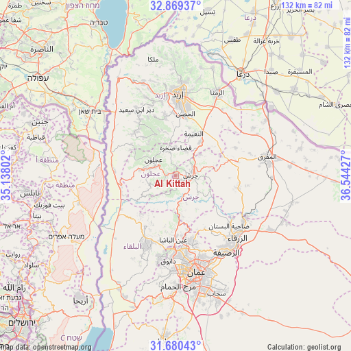
Al Kittah GPS coordinates[2]
32° 16' 36.66" North, 35° 50' 28.104" East
| Map corner | latitude | longitude |
|---|---|---|
| Upper-left | 32.86937°, | 35.13802° |
| Center: | 32.27685°, | 35.84114° |
| Lower-right: | 31.68043°, | 36.54427° |
| Map W x H: | 132.2×132.2 km | = 82.1×82.1mi |
| max Lat: | 33.31405° ⇑41.3% North |
| Al Kittah: | 32.27685° |
| min Lat: | ⇓58.7% South 29.40842° |
| min Long | Al Kittah | max Long |
| 34.97918° | 35.84114° | 38.70342° |
| W 58.7%⇐ | ⇒41.3% E |
Elevation
Elevation of Al Kittah is 698 m = 2290 ft, and this is 12.3 m = 40 ft above average elevation for this country.
| Max E: |
1440 m = 4724 ft | 53.6% |
| Al Kittah | 698 m 2290 ft | |
| Avg. | 685.7 m = 2250 ft | |
Min E: |
-366 m = -1201 ft | 46.4% |
See also: Jordan elevation on elevation.city.
Geographical zone
Al Kittah is located in North temperate zone (between Tropic of Cancer and the Arctic Circle). Distance of this Northern Tropic circle is 982.9 km =610.7 mi to South.| Distance of | km | miles | from Al Kittah |
|---|---|---|---|
| North Pole | 6418.2 | 3988.1 | to North |
| Arctic Circle | 3812.3 | 2368.9 | to North |
| Tropic Cancer | 982.9 | 610.7 | to South |
| Equator | 3588.8 | 2230 | to South |


Nearby cities:
15 places around Al Kittah: (largest is in red/bold)
• Al Maşţabah
10.4 km =6.5 mi,  172°
172°
• Balīlā
15.6 km =9.7 mi,  35°
35°
• Burmā
8.3 km =5.2 mi,  219°
219°
• Jarash
5.5 km =3.4 mi,  85°
85°
• Kitim
18.7 km =11.6 mi,  16°
16°
• Kufrinjah
13.3 km =8.3 mi,  279°
279°
• Qafqafā
12.1 km =7.5 mi,  48°
48°
• Raymūn
1.4 km =0.9 mi,  294°
294°
• Sakib
3.1 km =1.9 mi, 285°
• Sūf
4.1 km =2.5 mi,  354°
354°
• Şakhrah
10.5 km =6.5 mi,  0°
0°
• ‘Ajlūn
10.4 km =6.5 mi,  307°
307°
• ‘Anjarah
8.6 km =5.3 mi, 292°
• ‘Ayn Jannah
9.7 km =6 mi, 311°
• ‘Irjān
16.5 km =10.3 mi,  322°
322°
Sources, notices
• [Note1] Compared only with cities in Jordan existing in our database
• [Src1] Map data: © OpenStreetMap contributors (CC-BY-SA)
• [Src2] Other city data from geonames.org with taken over terms of usage.
• [Src3] Geographical zone / Annual Mean Temperature by Robert A. Rohde @ Wikipedia
