Qafqafā geodata
Qafqafā (Jerash) is a populated place; located in Jordan in Asia/Amman (GMT+3) time zone. With population of 4,402 people, there are 71 cities with bigger population in this country. Compared to other cities in Jordan, 69.6% of cities are located further ↓South; 72.5% of cities are located further ←West and 88.4% of cities have lower elevation than Qafqafā. Note1


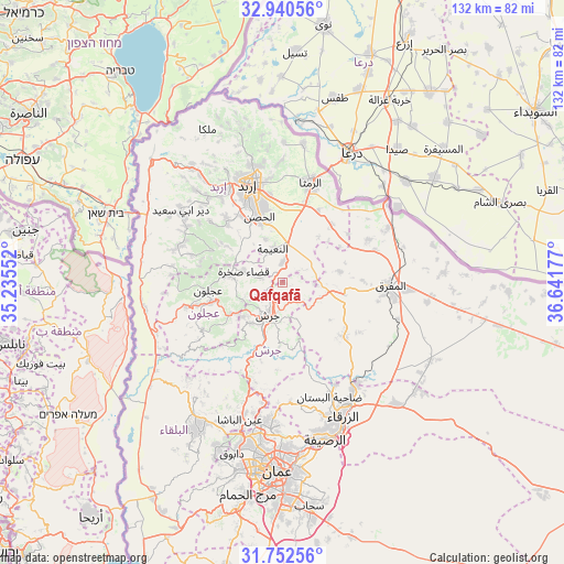
Qafqafā GPS coordinates[2]
32° 20' 54.636" North, 35° 56' 19.104" East
| Map corner | latitude | longitude |
|---|---|---|
| Upper-left | 32.94056°, | 35.23552° |
| Center: | 32.34851°, | 35.93864° |
| Lower-right: | 31.75256°, | 36.64177° |
| Map W x H: | 132.1×132.1 km | = 82.1×82.1mi |
| max Lat: | 33.31405° ⇑30.4% North |
| Qafqafā: | 32.34851° |
| min Lat: | ⇓69.6% South 29.40842° |
| min Long | Qafqafā | max Long |
| 34.97918° | 35.93864° | 38.70342° |
| W 72.5%⇐ | ⇒27.5% E |
Elevation
Elevation of Qafqafā is 998 m = 3274 ft, and this is 312.3 m = 1025 ft above average elevation for this country.
| Max E: |
1440 m = 4724 ft | 11.6% |
| Qafqafā | 998 m 3274 ft | |
| Avg. | 685.7 m = 2250 ft | |
Min E: |
-366 m = -1201 ft | 88.4% |
See also: Jordan elevation on elevation.city.
Geographical zone
Qafqafā is located in North temperate zone (between Tropic of Cancer and the Arctic Circle). Distance of this Northern Tropic circle is 990.9 km =615.7 mi to South.| Distance of | km | miles | from Qafqafā |
|---|---|---|---|
| North Pole | 6410.2 | 3983.1 | to North |
| Arctic Circle | 3804.4 | 2363.9 | to North |
| Tropic Cancer | 990.9 | 615.7 | to South |
| Equator | 3596.8 | 2234.9 | to South |


Nearby cities:
15 places around Qafqafā: (largest is in red/bold)
• Al Kittah
12.1 km =7.5 mi,  228°
228°
• Al Ḩişn
16 km =9.9 mi,  341°
341°
• Balīlā
4.7 km =2.9 mi,  359°
359°
• Bal‘amā
18.8 km =11.7 mi,  131°
131°
• Jarash
8.4 km =5.2 mi,  206°
206°
• Kitim
10.7 km =6.6 mi, 338°
• Manshīyat Banī Ḩasan
13.4 km =8.3 mi,  79°
79°
• Raymūn
12.8 km =8 mi, 234°
• Rehab
14.6 km =9.1 mi,  101°
101°
• Sakib
14.1 km =8.8 mi,  239°
239°
• Sūf
10.3 km =6.4 mi,  247°
247°
• Şakhrah
9.4 km =5.8 mi,  285°
285°
• ‘Ajlūn
17.5 km =10.9 mi,  264°
264°
• ‘Anjarah
17.7 km =11 mi, 254°
• ‘Ayn Jannah
16.5 km =10.3 mi, 264°
Sources, notices
• [Note1] Compared only with cities in Jordan existing in our database
• [Src1] Map data: © OpenStreetMap contributors (CC-BY-SA)
• [Src2] Other city data from geonames.org with taken over terms of usage.
• [Src3] Geographical zone / Annual Mean Temperature by Robert A. Rohde @ Wikipedia
