Tennō geodata
Tennō (Akita) is a populated place; located in Japan in Asia/Tokyo (GMT+9) time zone. With population of 22,740 people, there are 647 cities with bigger population in this country. Compared to other cities in Japan, 93.1% of cities are located further ↓South; 77.5% of cities are located further ←West and 86% of cities have higher elevation than Tennō. Note1


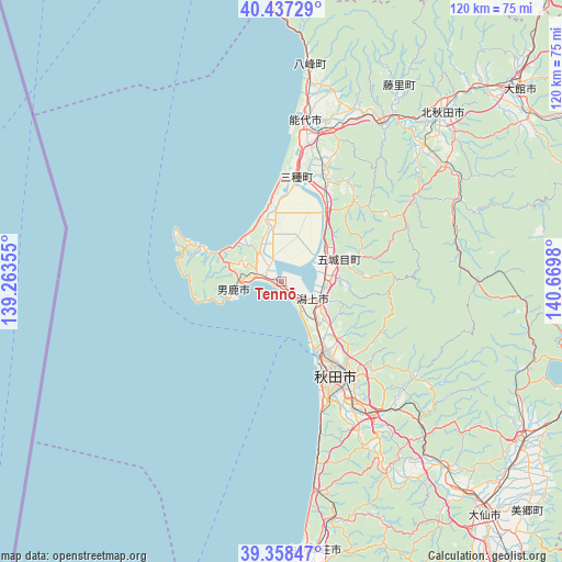
Tennō GPS coordinates[2]
39° 54' 0" North, 139° 58' 0.012" East
| Map corner | latitude | longitude |
|---|---|---|
| Upper-left | 40.43729°, | 139.26355° |
| Center: | 39.9°, | 139.96667° |
| Lower-right: | 39.35847°, | 140.6698° |
| Map W x H: | 120×120 km | = 74.6×74.6mi |
| max Lat: | 45.40944° ⇑6.9% North |
| Tennō: | 39.9° |
| min Lat: | ⇓93.1% South 24.34478° |
| min Long | Tennō | max Long |
| 123° | 139.96667° | 145.575° |
| W 77.5%⇐ | ⇒22.5% E |
Elevation
Elevation of Tennō is 6 m = 20 ft, and this is 78.6 m = 258 ft below average elevation for this country.
| Max E: |
1086 m = 3563 ft | 86% |
| Avg. | 84.6 m = 278 ft | |
| Tennō | 6 m = 20 ft | |
Min E: |
-2 m = -7 ft | 14% |
See also: Japan elevation on elevation.city.
Geographical zone
Tennō is located in North temperate zone (between Tropic of Cancer and the Arctic Circle). Distance of this Northern Tropic circle is 1830.5 km =1137.4 mi to South.| Distance of | km | miles | from Tennō |
|---|---|---|---|
| North Pole | 5570.6 | 3461.4 | to North |
| Arctic Circle | 2964.7 | 1842.2 | to North |
| Tropic Cancer | 1830.5 | 1137.4 | to South |
| Equator | 4436.5 | 2756.7 | to South |


Nearby cities:
15 places around Tennō: (largest is in red/bold)
• Akita
24.1 km =15 mi,  147°
147°
• Daisen
67.9 km =42.2 mi,  138°
138°
• Hanawa
76.6 km =47.6 mi,  65°
65°
• Kakunodatemachi
61.9 km =38.5 mi,  123°
123°
• Katagami
3.6 km =2.2 mi,  131°
131°
• Kazuno
77.5 km =48.2 mi,  63°
63°
• Kita-Akita
49.3 km =30.6 mi,  47°
47°
• Nikaho
70 km =43.5 mi,  181°
181°
• Noshiro
34.7 km =21.6 mi,  8°
8°
• Oga
10.5 km =6.5 mi,  252°
252°
• Semboku
69.9 km =43.4 mi,  107°
107°
• Takanosu
49.4 km =30.7 mi,  43°
43°
• Yurihonjō
57.3 km =35.6 mi,  172°
172°
• Ōdate
65.1 km =40.5 mi, 50°
• Ōmagari
66.8 km =41.5 mi, 138°
Sources, notices
• [Note1] Compared only with cities in Japan existing in our database
• [Src1] Map data: © OpenStreetMap contributors (CC-BY-SA)
• [Src2] Other city data from geonames.org with taken over terms of usage.
• [Src3] Geographical zone / Annual Mean Temperature by Robert A. Rohde @ Wikipedia
