Akita geodata
Akita is a seat of a first-order administrative division; located in Japan in Asia/Tokyo (GMT+9) time zone. With population of 320,069 people, there are 60 cities with bigger population in this country. Compared to other cities in Japan, 92.7% of cities are located further ↓South; 80.7% of cities are located further ←West and 66.8% of cities have higher elevation than Akita. Note1


Akita GPS coordinates[2]
39° 43' 0.012" North, 140° 7' 0.012" East
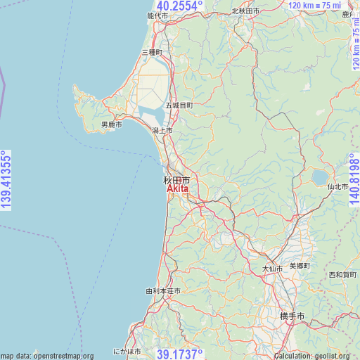
| Map corner | latitude | longitude |
|---|---|---|
| Upper-left | 40.2554°, | 139.41355° |
| Center: | 39.71667°, | 140.11667° |
| Lower-right: | 39.1737°, | 140.8198° |
| Map W x H: | 120.3×120.3 km | = 74.8×74.8mi |
| max Lat: | 45.40944° ⇑7.3% North |
| Akita: | 39.71667° |
| min Lat: | ⇓92.7% South 24.34478° |
| min Long | Akita | max Long |
| 123° | 140.11667° | 145.575° |
| W 80.7%⇐ | ⇒19.3% E |
Elevation
Elevation of Akita is 14 m = 46 ft, and this is 70.6 m = 232 ft below average elevation for this country.
| Max E: |
1086 m = 3563 ft | 66.8% |
| Avg. | 84.6 m = 278 ft | |
| Akita | 14 m = 46 ft | |
Min E: |
-2 m = -7 ft | 33.2% |
See also: Akita elevation on elevation.city.
Geographical zone
Akita is located in North temperate zone (between Tropic of Cancer and the Arctic Circle). Distance of this Northern Tropic circle is 1810.2 km =1124.8 mi to South.| Distance of | km | miles | from Akita |
|---|---|---|---|
| North Pole | 5591 | 3474.1 | to North |
| Arctic Circle | 2985.1 | 1854.9 | to North |
| Tropic Cancer | 1810.2 | 1124.8 | to South |
| Equator | 4416.1 | 2744 | to South |


Nearby cities:
15 places around Akita: (largest is in red/bold)
• Daisen
44.3 km =27.5 mi,  133°
133°
• Kakunodatemachi
41.1 km =25.5 mi,  110°
110°
• Katagami
20.7 km =12.9 mi,  330°
330°
• Kita-Akita
58.7 km =36.5 mi,  23°
23°
• Nikaho
51.9 km =32.2 mi,  197°
197°
• Noshiro
55.2 km =34.3 mi,  352°
352°
• Oga
28.6 km =17.8 mi,  306°
306°
• Semboku
53.9 km =33.5 mi,  90°
90°
• Takanosu
60.1 km =37.3 mi, 20°
• Tennō
24.1 km =15 mi, 327°
• Yokote
58 km =36 mi,  140°
140°
• Yurihonjō
36.7 km =22.8 mi,  187°
187°
• Yuzawa
69.4 km =43.1 mi,  151°
151°
• Ōdate
72.3 km =44.9 mi,  31°
31°
• Ōmagari
43.2 km =26.8 mi, 133°
Sources, notices
• [Note1] Compared only with cities in Japan existing in our database
• [Src1] Map data: © OpenStreetMap contributors (CC-BY-SA)
• [Src2] Other city data from geonames.org with taken over terms of usage.
• [Src3] Geographical zone / Annual Mean Temperature by Robert A. Rohde @ Wikipedia
