Yurihonjō geodata
Yurihonjō (Akita) is a seat of a second-order administrative division; located in Japan in Asia/Tokyo (GMT+9) time zone. In our database, there are 767 cities with bigger population. Compared to other cities in Japan, 91.8% of cities are located further ↓South; 79.7% of cities are located further ←West and 93.5% of cities have higher elevation than Yurihonjō. Note1


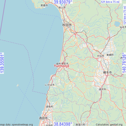
Yurihonjō GPS coordinates[2]
39° 23' 22.2" North, 140° 3' 29.268" East
| Map corner | latitude | longitude |
|---|---|---|
| Upper-left | 39.93079°, | 139.35501° |
| Center: | 39.3895°, | 140.05813° |
| Lower-right: | 38.84398°, | 140.76126° |
| Map W x H: | 120.8×120.8 km | = 75.1×75.1mi |
| max Lat: | 45.40944° ⇑8.2% North |
| Yurihonjō: | 39.3895° |
| min Lat: | ⇓91.8% South 24.34478° |
| min Long | Yurihonjō | max Long |
| 123° | 140.05813° | 145.575° |
| W 79.7%⇐ | ⇒20.3% E |
Elevation
Elevation of Yurihonjō is 4 m = 13 ft, and this is 80.6 m = 264 ft below average elevation for this country.
| Max E: |
1086 m = 3563 ft | 93.5% |
| Avg. | 84.6 m = 278 ft | |
| Yurihonjō | 4 m = 13 ft | |
Min E: |
-2 m = -7 ft | 6.5% |
See also: Japan elevation on elevation.city.
Geographical zone
Yurihonjō is located in North temperate zone (between Tropic of Cancer and the Arctic Circle). Distance of this Northern Tropic circle is 1773.8 km =1102.2 mi to South.| Distance of | km | miles | from Yurihonjō |
|---|---|---|---|
| North Pole | 5627.4 | 3496.7 | to North |
| Arctic Circle | 3021.5 | 1877.5 | to North |
| Tropic Cancer | 1773.8 | 1102.2 | to South |
| Equator | 4379.7 | 2721.4 | to South |


Nearby cities:
15 places around Yurihonjō: (largest is in red/bold)
• Akita
36.7 km =22.8 mi,  7°
7°
• Daisen
37.5 km =23.3 mi,  81°
81°
• Kakunodatemachi
49 km =30.4 mi,  63°
63°
• Katagami
54.6 km =33.9 mi,  354°
354°
• Nikaho
16.7 km =10.4 mi,  217°
217°
• Oga
56.4 km =35 mi,  341°
341°
• Sakata
55.4 km =34.4 mi,  198°
198°
• Semboku
68.9 km =42.8 mi, 58°
• Shinjō
73.2 km =45.5 mi,  163°
163°
• Tennō
57.3 km =35.6 mi, 352°
• Tsuruoka
77 km =47.8 mi, 195°
• Yokote
43.1 km =26.8 mi,  100°
100°
• Yuza
43 km =26.7 mi,  194°
194°
• Yuzawa
45.4 km =28.2 mi,  123°
123°
• Ōmagari
37.1 km =23.1 mi, 79°
Sources, notices
• [Note1] Compared only with cities in Japan existing in our database
• [Src1] Map data: © OpenStreetMap contributors (CC-BY-SA)
• [Src2] Other city data from geonames.org with taken over terms of usage.
• [Src3] Geographical zone / Annual Mean Temperature by Robert A. Rohde @ Wikipedia
