Ōmamachō-ōmama geodata
Ōmamachō-ōmama (Gunma) is a populated place; located in Japan in Asia/Tokyo (GMT+9) time zone. With population of 21,286 people, there are 674 cities with bigger population in this country. Compared to other cities in Japan, 76.4% of cities are located further ↓South; 64% of cities are located further ←West and 86.1% of cities have lower elevation than Ōmamachō-ōmama. Note1


Ōmamachō-ōmama GPS coordinates[2]
36° 25' 54.516" North, 139° 16' 31.224" East
| Map corner | latitude | longitude |
|---|---|---|
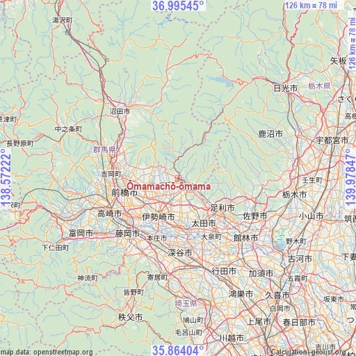
| Upper-left | 36.99545°, | 138.57222° |
| Center: | 36.43181°, | 139.27534° |
| Lower-right: | 35.86404°, | 139.97847° |
| Map W x H: | 125.8×125.8 km | = 78.2×78.2mi |
| max Lat: | 45.40944° ⇑23.6% North |
| Ōmamachō-ōmama: | 36.43181° |
| min Lat: | ⇓76.4% South 24.34478° |
| min Long | Ōmamachō-ōma | max Long |
| 123° | 139.27534° | 145.575° |
| W 64%⇐ | ⇒36% E |
Elevation
Elevation of Ōmamachō-ōmama is 182 m = 597 ft, and this is 97.4 m = 320 ft above average elevation for this country.
| Max E: |
1086 m = 3563 ft | 13.9% |
| Ōmamachō-ōmama | 182 m 597 ft | |
| Avg. | 84.6 m = 278 ft | |
Min E: |
-2 m = -7 ft | 86.1% |
See also: Japan elevation on elevation.city.
Geographical zone
Ōmamachō-ōmama is located in North temperate zone (between Tropic of Cancer and the Arctic Circle). Distance of this Northern Tropic circle is 1444.9 km =897.8 mi to South.| Distance of | km | miles | from Ōmamachō-ōmama |
|---|---|---|---|
| North Pole | 5956.2 | 3701 | to North |
| Arctic Circle | 3350.3 | 2081.8 | to North |
| Tropic Cancer | 1444.9 | 897.8 | to South |
| Equator | 4050.8 | 2517 | to South |


Nearby cities:
15 places around Ōmamachō-ōmama: (largest is in red/bold)
• Ashikaga
19.1 km =11.9 mi,  125°
125°
• Fujioka
27.5 km =17.1 mi,  221°
221°
• Fukayachō
25.8 km =16 mi,  178°
178°
• Honjō
22.9 km =14.2 mi,  199°
199°
• Isesaki
14.5 km =9 mi,  207°
207°
• Kanekomachi
25.1 km =15.6 mi,  264°
264°
• Kiryū
6.3 km =3.9 mi,  124°
124°
• Maebashi
17.5 km =10.9 mi, 258°
• Menuma
25.2 km =15.7 mi,  157°
157°
• Midori
1.7 km =1.1 mi,  29°
29°
• Sakai-nakajima
18.5 km =11.5 mi,  187°
187°
• Shibukawa
25.3 km =15.7 mi,  283°
283°
• Takasaki
25.6 km =15.9 mi,  244°
244°
• Tamamura
20.4 km =12.7 mi, 224°
• Ōta
16.8 km =10.4 mi,  150°
150°
Sources, notices
• [Note1] Compared only with cities in Japan existing in our database
• [Src1] Map data: © OpenStreetMap contributors (CC-BY-SA)
• [Src2] Other city data from geonames.org with taken over terms of usage.
• [Src3] Geographical zone / Annual Mean Temperature by Robert A. Rohde @ Wikipedia
