Nakamura geodata
Nakamura (Kochi) is a populated place; located in Japan in Asia/Tokyo (GMT+9) time zone. With population of 34,559 people, there are 502 cities with bigger population in this country. Compared to other cities in Japan, 90.9% of cities are located further ↑North; 79.5% of cities are located further →East and 81.8% of cities have higher elevation than Nakamura. Note1


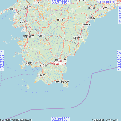
Nakamura GPS coordinates[2]
32° 58' 59.988" North, 132° 55' 59.988" East
| Map corner | latitude | longitude |
|---|---|---|
| Upper-left | 33.57116°, | 132.23021° |
| Center: | 32.98333°, | 132.93333° |
| Lower-right: | 32.39156°, | 133.63646° |
| Map W x H: | 131.2×131.2 km | = 81.5×81.5mi |
| max Lat: | 45.40944° ⇑90.9% North |
| Nakamura: | 32.98333° |
| min Lat: | ⇓9.1% South 24.34478° |
| min Long | Nakamura | max Long |
| 123° | 132.93333° | 145.575° |
| W 20.5%⇐ | ⇒79.5% E |
Elevation
Elevation of Nakamura is 7 m = 23 ft, and this is 77.6 m = 255 ft below average elevation for this country.
| Max E: |
1086 m = 3563 ft | 81.8% |
| Avg. | 84.6 m = 278 ft | |
| Nakamura | 7 m = 23 ft | |
Min E: |
-2 m = -7 ft | 18.2% |
See also: Japan elevation on elevation.city.
Geographical zone
Nakamura is located in North temperate zone (between Tropic of Cancer and the Arctic Circle). Distance of this Northern Tropic circle is 1061.5 km =659.6 mi to South.| Distance of | km | miles | from Nakamura |
|---|---|---|---|
| North Pole | 6339.7 | 3939.3 | to North |
| Arctic Circle | 3733.8 | 2320.1 | to North |
| Tropic Cancer | 1061.5 | 659.6 | to South |
| Equator | 3667.4 | 2278.8 | to South |


Nearby cities:
15 places around Nakamura: (largest is in red/bold)
• Ikata-chō
77.8 km =48.3 mi,  316°
316°
• Ino
78.3 km =48.7 mi,  36°
36°
• Iyo
88.1 km =54.7 mi,  345°
345°
• Kihoku-chō
38.2 km =23.7 mi, 322°
• Kochi
84.2 km =52.3 mi, 41°
• Seiyo
53 km =32.9 mi,  328°
328°
• Shimanto
13 km =8.1 mi, 324°
• Sukumo
19.5 km =12.1 mi,  253°
253°
• Susaki
56.6 km =35.2 mi, 36°
• Tosa
75 km =46.6 mi, 39°
• Tosashimizu
22.3 km =13.9 mi,  172°
172°
• Tōon
90.3 km =56.1 mi,  357°
357°
• Uwajima
43.9 km =27.3 mi,  307°
307°
• Yawatahama
70.3 km =43.7 mi, 318°
• Ōzu
67.6 km =42 mi, 328°
Sources, notices
• [Note1] Compared only with cities in Japan existing in our database
• [Src1] Map data: © OpenStreetMap contributors (CC-BY-SA)
• [Src2] Other city data from geonames.org with taken over terms of usage.
• [Src3] Geographical zone / Annual Mean Temperature by Robert A. Rohde @ Wikipedia
