Sukumo geodata
Sukumo (Kochi) is a seat of a second-order administrative division; located in Japan in Asia/Tokyo (GMT+9) time zone. With population of 25,784 people, there are 601 cities with bigger population in this country. Compared to other cities in Japan, 91.7% of cities are located further ↑North; 80.6% of cities are located further →East and 69.3% of cities have higher elevation than Sukumo. Note1


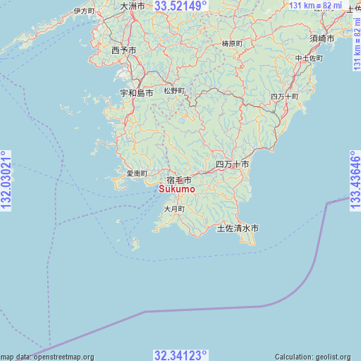
Sukumo GPS coordinates[2]
32° 55' 59.988" North, 132° 43' 59.988" East
| Map corner | latitude | longitude |
|---|---|---|
| Upper-left | 33.52149°, | 132.03021° |
| Center: | 32.93333°, | 132.73333° |
| Lower-right: | 32.34123°, | 133.43646° |
| Map W x H: | 131.2×131.2 km | = 81.5×81.5mi |
| max Lat: | 45.40944° ⇑91.7% North |
| Sukumo: | 32.93333° |
| min Lat: | ⇓8.3% South 24.34478° |
| min Long | Sukumo | max Long |
| 123° | 132.73333° | 145.575° |
| W 19.4%⇐ | ⇒80.6% E |
Elevation
Elevation of Sukumo is 12 m = 39 ft, and this is 72.6 m = 238 ft below average elevation for this country.
| Max E: |
1086 m = 3563 ft | 69.3% |
| Avg. | 84.6 m = 278 ft | |
| Sukumo | 12 m = 39 ft | |
Min E: |
-2 m = -7 ft | 30.7% |
See also: Japan elevation on elevation.city.
Geographical zone
Sukumo is located in North temperate zone (between Tropic of Cancer and the Arctic Circle). Distance of this Northern Tropic circle is 1055.9 km =656.1 mi to South.| Distance of | km | miles | from Sukumo |
|---|---|---|---|
| North Pole | 6345.2 | 3942.7 | to North |
| Arctic Circle | 3739.3 | 2323.5 | to North |
| Tropic Cancer | 1055.9 | 656.1 | to South |
| Equator | 3661.8 | 2275.3 | to South |


Nearby cities:
15 places around Sukumo: (largest is in red/bold)
• Ikata-chō
71.1 km =44.2 mi,  330°
330°
• Iyo
91 km =56.5 mi,  358°
358°
• Kihoku-chō
36.2 km =22.5 mi,  352°
352°
• Nakamura
19.5 km =12.1 mi,  73°
73°
• Saiki
77.8 km =48.3 mi,  271°
271°
• Seiyo
51.4 km =31.9 mi, 349°
• Shimanto
19.6 km =12.2 mi,  34°
34°
• Susaki
73 km =45.4 mi,  45°
45°
• Tosa
91.7 km =57 mi, 46°
• Tosashimizu
27.1 km =16.8 mi,  127°
127°
• Tsukumiura
82.1 km =51 mi,  281°
281°
• Usuki
89.2 km =55.4 mi, 283°
• Uwajima
36.1 km =22.4 mi, 333°
• Yawatahama
64.6 km =40.1 mi, 334°
• Ōzu
65.3 km =40.6 mi,  344°
344°
Sources, notices
• [Note1] Compared only with cities in Japan existing in our database
• [Src1] Map data: © OpenStreetMap contributors (CC-BY-SA)
• [Src2] Other city data from geonames.org with taken over terms of usage.
• [Src3] Geographical zone / Annual Mean Temperature by Robert A. Rohde @ Wikipedia
