Shimanto geodata
Shimanto (Kochi) is a seat of a second-order administrative division; located in Japan in Asia/Tokyo (GMT+9) time zone. In our database, there are 767 cities with bigger population. Compared to other cities in Japan, 90.4% of cities are located further ↑North; 79.9% of cities are located further →East and 91.5% of cities have lower elevation than Shimanto. Note1


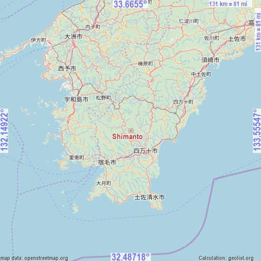
Shimanto GPS coordinates[2]
33° 4' 41.916" North, 132° 51' 8.424" East
| Map corner | latitude | longitude |
|---|---|---|
| Upper-left | 33.6655°, | 132.14922° |
| Center: | 33.07831°, | 132.85234° |
| Lower-right: | 32.48718°, | 133.55547° |
| Map W x H: | 131×131 km | = 81.4×81.4mi |
| max Lat: | 45.40944° ⇑90.4% North |
| Shimanto: | 33.07831° |
| min Lat: | ⇓9.6% South 24.34478° |
| min Long | Shimanto | max Long |
| 123° | 132.85234° | 145.575° |
| W 20.1%⇐ | ⇒79.9% E |
Elevation
Elevation of Shimanto is 252 m = 827 ft, and this is 167.4 m = 549 ft above average elevation for this country.
| Max E: |
1086 m = 3563 ft | 8.5% |
| Shimanto | 252 m 827 ft | |
| Avg. | 84.6 m = 278 ft | |
Min E: |
-2 m = -7 ft | 91.5% |
See also: Japan elevation on elevation.city.
Geographical zone
Shimanto is located in North temperate zone (between Tropic of Cancer and the Arctic Circle). Distance of this Northern Tropic circle is 1072 km =666.1 mi to South.| Distance of | km | miles | from Shimanto |
|---|---|---|---|
| North Pole | 6329.1 | 3932.7 | to North |
| Arctic Circle | 3723.2 | 2313.5 | to North |
| Tropic Cancer | 1072 | 666.1 | to South |
| Equator | 3678 | 2285.4 | to South |


Nearby cities:
15 places around Shimanto: (largest is in red/bold)
• Ikata-chō
65 km =40.4 mi,  314°
314°
• Ino
75.3 km =46.8 mi,  45°
45°
• Iyo
76.1 km =47.3 mi,  349°
349°
• Kihoku-chō
25.2 km =15.7 mi,  321°
321°
• Masaki-chō
79.9 km =49.6 mi, 350°
• Nakamura
13 km =8.1 mi,  144°
144°
• Seiyo
40.1 km =24.9 mi,  329°
329°
• Sukumo
19.6 km =12.2 mi,  214°
214°
• Susaki
53.9 km =33.5 mi, 49°
• Tosa
72.7 km =45.2 mi, 49°
• Tosashimizu
34.3 km =21.3 mi,  162°
162°
• Tōon
79.7 km =49.5 mi,  2°
2°
• Uwajima
31.7 km =19.7 mi,  300°
300°
• Yawatahama
57.4 km =35.7 mi, 317°
• Ōzu
54.7 km =34 mi, 329°
Sources, notices
• [Note1] Compared only with cities in Japan existing in our database
• [Src1] Map data: © OpenStreetMap contributors (CC-BY-SA)
• [Src2] Other city data from geonames.org with taken over terms of usage.
• [Src3] Geographical zone / Annual Mean Temperature by Robert A. Rohde @ Wikipedia
