Ebino geodata
Ebino (Miyazaki) is a seat of a second-order administrative division; located in Japan in Asia/Tokyo (GMT+9) time zone. In our database, there are 767 cities with bigger population. Compared to other cities in Japan, 94.9% of cities are located further ↑North; 88.1% of cities are located further →East and 90.9% of cities have lower elevation than Ebino. Note1


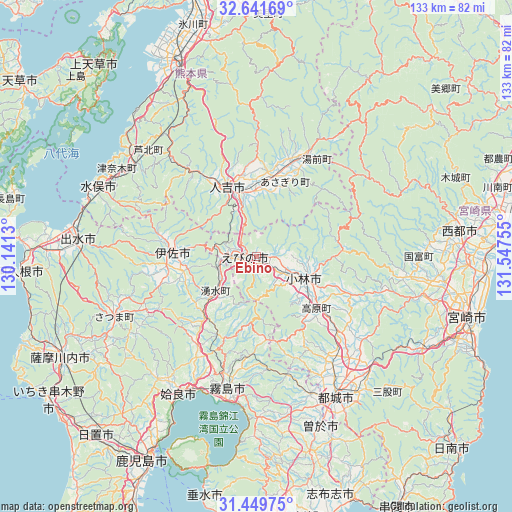
Ebino GPS coordinates[2]
32° 2' 51.576" North, 130° 50' 39.912" East
| Map corner | latitude | longitude |
|---|---|---|
| Upper-left | 32.64169°, | 130.1413° |
| Center: | 32.04766°, | 130.84442° |
| Lower-right: | 31.44975°, | 131.54755° |
| Map W x H: | 132.5×132.5 km | = 82.3×82.3mi |
| max Lat: | 45.40944° ⇑94.9% North |
| Ebino: | 32.04766° |
| min Lat: | ⇓5.1% South 24.34478° |
| min Long | Ebino | max Long |
| 123° | 130.84442° | 145.575° |
| W 11.9%⇐ | ⇒88.1% E |
Elevation
Elevation of Ebino is 239 m = 784 ft, and this is 154.4 m = 507 ft above average elevation for this country.
| Max E: |
1086 m = 3563 ft | 9.1% |
| Ebino | 239 m 784 ft | |
| Avg. | 84.6 m = 278 ft | |
Min E: |
-2 m = -7 ft | 90.9% |
See also: Japan elevation on elevation.city.
Geographical zone
Ebino is located in North temperate zone (between Tropic of Cancer and the Arctic Circle). Distance of this Northern Tropic circle is 957.4 km =594.9 mi to South.| Distance of | km | miles | from Ebino |
|---|---|---|---|
| North Pole | 6443.7 | 4003.9 | to North |
| Arctic Circle | 3837.8 | 2384.7 | to North |
| Tropic Cancer | 957.4 | 594.9 | to South |
| Equator | 3563.4 | 2214.2 | to South |


Nearby cities:
15 places around Ebino: (largest is in red/bold)
• Aira
38.6 km =24 mi,  218°
218°
• Hamanoichi
38.3 km =23.8 mi,  195°
195°
• Hitoyoshi
20.8 km =12.9 mi,  334°
334°
• Isa
22 km =13.7 mi,  275°
275°
• Izumi
45.2 km =28.1 mi, 275°
• Kajiki
38.8 km =24.1 mi,  205°
205°
• Kirishima
35 km =21.7 mi,  192°
192°
• Kobayashi
14.9 km =9.3 mi,  118°
118°
• Kokubu-matsuki
35.7 km =22.2 mi, 191°
• Minamata
45.9 km =28.5 mi,  294°
294°
• Miyakonojō
40.8 km =25.4 mi,  149°
149°
• Soo
46.7 km =29 mi,  162°
162°
• Sueyoshichō-ninokata
47.1 km =29.3 mi, 159°
• Yotsueda
10.9 km =6.8 mi,  250°
250°
• Ōkuchi-shinohara
20.9 km =13 mi, 276°
Sources, notices
• [Note1] Compared only with cities in Japan existing in our database
• [Src1] Map data: © OpenStreetMap contributors (CC-BY-SA)
• [Src2] Other city data from geonames.org with taken over terms of usage.
• [Src3] Geographical zone / Annual Mean Temperature by Robert A. Rohde @ Wikipedia
