Yotsueda geodata
Yotsueda (Kagoshima) is a populated locality; located in Japan in Asia/Tokyo (GMT+9) time zone. With population of 1,000 people, there are 765 cities with bigger population in this country. Compared to other cities in Japan, 95% of cities are located further ↑North; 89% of cities are located further →East and 91.1% of cities have lower elevation than Yotsueda. Note1


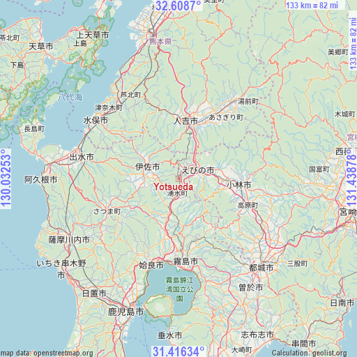
Yotsueda GPS coordinates[2]
32° 0' 52.056" North, 130° 44' 8.34" East
| Map corner | latitude | longitude |
|---|---|---|
| Upper-left | 32.6087°, | 130.03253° |
| Center: | 32.01446°, | 130.73565° |
| Lower-right: | 31.41634°, | 131.43878° |
| Map W x H: | 132.6×132.6 km | = 82.4×82.4mi |
| max Lat: | 45.40944° ⇑95% North |
| Yotsueda: | 32.01446° |
| min Lat: | ⇓5% South 24.34478° |
| min Long | Yotsueda | max Long |
| 123° | 130.73565° | 145.575° |
| W 11%⇐ | ⇒89% E |
Elevation
Elevation of Yotsueda is 248 m = 814 ft, and this is 163.4 m = 536 ft above average elevation for this country.
| Max E: |
1086 m = 3563 ft | 8.9% |
| Yotsueda | 248 m 814 ft | |
| Avg. | 84.6 m = 278 ft | |
Min E: |
-2 m = -7 ft | 91.1% |
See also: Japan elevation on elevation.city.
Geographical zone
Yotsueda is located in North temperate zone (between Tropic of Cancer and the Arctic Circle). Distance of this Northern Tropic circle is 953.8 km =592.7 mi to South.| Distance of | km | miles | from Yotsueda |
|---|---|---|---|
| North Pole | 6447.4 | 4006.2 | to North |
| Arctic Circle | 3841.5 | 2387 | to North |
| Tropic Cancer | 953.8 | 592.7 | to South |
| Equator | 3559.7 | 2211.9 | to South |


Nearby cities:
15 places around Yotsueda: (largest is in red/bold)
• Aira
29.9 km =18.6 mi,  206°
206°
• Ebino
10.9 km =6.8 mi,  70°
70°
• Hamanoichi
33.1 km =20.6 mi,  180°
180°
• Hitoyoshi
22.5 km =14 mi,  3°
3°
• Isa
13.1 km =8.1 mi,  296°
296°
• Izumi
35.6 km =22.1 mi,  282°
282°
• Kajiki
31.9 km =19.8 mi,  191°
191°
• Kirishima
30.5 km =19 mi, 175°
• Kobayashi
23.6 km =14.7 mi,  98°
98°
• Kokubu-matsuki
31.4 km =19.5 mi,  174°
174°
• Minamata
38.8 km =24.1 mi,  305°
305°
• Miyakonojō
44.2 km =27.5 mi,  135°
135°
• Satsumasendai
46.6 km =29 mi,  241°
241°
• Soo
47.5 km =29.5 mi,  149°
149°
• Ōkuchi-shinohara
12 km =7.5 mi, 299°
Sources, notices
• [Note1] Compared only with cities in Japan existing in our database
• [Src1] Map data: © OpenStreetMap contributors (CC-BY-SA)
• [Src2] Other city data from geonames.org with taken over terms of usage.
• [Src3] Geographical zone / Annual Mean Temperature by Robert A. Rohde @ Wikipedia
