Kameoka geodata
Kameoka (Kyoto) is a seat of a second-order administrative division; located in Japan in Asia/Tokyo (GMT+9) time zone. With population of 97,181 people, there are 209 cities with bigger population in this country. Compared to other cities in Japan, 58.9% of cities are located further ↑North; 66.1% of cities are located further →East and 81.1% of cities have lower elevation than Kameoka. Note1


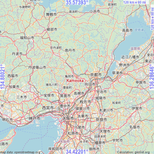
Kameoka GPS coordinates[2]
35° 0' 0" North, 135° 34' 59.988" East
| Map corner | latitude | longitude |
|---|---|---|
| Upper-left | 35.57393°, | 134.88021° |
| Center: | 35°, | 135.58333° |
| Lower-right: | 34.42201°, | 136.28646° |
| Map W x H: | 128.1×128.1 km | = 79.6×79.6mi |
| max Lat: | 45.40944° ⇑58.9% North |
| Kameoka: | 35° |
| min Lat: | ⇓41.1% South 24.34478° |
| min Long | Kameoka | max Long |
| 123° | 135.58333° | 145.575° |
| W 33.9%⇐ | ⇒66.1% E |
Elevation
Elevation of Kameoka is 129 m = 423 ft, and this is 44.4 m = 146 ft above average elevation for this country.
| Max E: |
1086 m = 3563 ft | 18.9% |
| Kameoka | 129 m 423 ft | |
| Avg. | 84.6 m = 278 ft | |
Min E: |
-2 m = -7 ft | 81.1% |
See also: Kameoka elevation on elevation.city.
Geographical zone
Kameoka is located in North temperate zone (between Tropic of Cancer and the Arctic Circle). Distance of this Northern Tropic circle is 1285.7 km =798.9 mi to South.| Distance of | km | miles | from Kameoka |
|---|---|---|---|
| North Pole | 6115.4 | 3799.9 | to North |
| Arctic Circle | 3509.5 | 2180.7 | to North |
| Tropic Cancer | 1285.7 | 798.9 | to South |
| Equator | 3891.6 | 2418.1 | to South |


Nearby cities:
15 places around Kameoka: (largest is in red/bold)
• Arashiyama
8.7 km =5.4 mi,  79°
79°
• Hirakata
21.6 km =13.4 mi,  163°
163°
• Ibaraki
20.5 km =12.7 mi,  183°
183°
• Ikeda
24.2 km =15 mi,  215°
215°
• Kamigyō-ku
16.1 km =10 mi, 78°
• Kawanishi
21.4 km =13.3 mi,  231°
231°
• Kyoto
15.7 km =9.8 mi, 81°
• Mino
21.8 km =13.5 mi,  208°
208°
• Mukō
11.7 km =7.3 mi,  109°
109°
• Nagaoka
12.5 km =7.8 mi,  127°
127°
• Nantan
14.8 km =9.2 mi,  325°
325°
• Settsu
24.7 km =15.3 mi, 177°
• Takatsuki
17.1 km =10.6 mi,  169°
169°
• Uji
23.5 km =14.6 mi,  121°
121°
• Yawata
18.1 km =11.2 mi,  143°
143°
Sources, notices
• [Note1] Compared only with cities in Japan existing in our database
• [Src1] Map data: © OpenStreetMap contributors (CC-BY-SA)
• [Src2] Other city data from geonames.org with taken over terms of usage.
• [Src3] Geographical zone / Annual Mean Temperature by Robert A. Rohde @ Wikipedia
