Sakata geodata
Sakata (Yamagata) is a seat of a second-order administrative division; located in Japan in Asia/Tokyo (GMT+9) time zone. With population of 100,446 people, there are 201 cities with bigger population in this country. Compared to other cities in Japan, 90.5% of cities are located further ↓South; 75.3% of cities are located further ←West and 99.3% of cities have higher elevation than Sakata. Note1


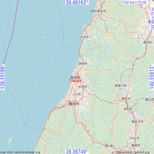
Sakata GPS coordinates[2]
38° 55' 0.012" North, 139° 51' 18" East
| Map corner | latitude | longitude |
|---|---|---|
| Upper-left | 39.46163°, | 139.15188° |
| Center: | 38.91667°, | 139.855° |
| Lower-right: | 38.36749°, | 140.55813° |
| Map W x H: | 121.7×121.7 km | = 75.6×75.6mi |
| max Lat: | 45.40944° ⇑9.5% North |
| Sakata: | 38.91667° |
| min Lat: | ⇓90.5% South 24.34478° |
| min Long | Sakata | max Long |
| 123° | 139.855° | 145.575° |
| W 75.3%⇐ | ⇒24.7% E |
Elevation
Elevation of Sakata is 0 m = 0 ft, and this is 84.6 m = 278 ft below average elevation for this country.
| Max E: |
1086 m = 3563 ft | 99.3% |
| Avg. | 84.6 m = 278 ft | |
| Sakata | 0 m = 0 ft | |
Min E: |
-2 m = -7 ft | 0.7% |
See also: Sakata elevation on elevation.city.
Geographical zone
Sakata is located in North temperate zone (between Tropic of Cancer and the Arctic Circle). Distance of this Northern Tropic circle is 1721.2 km =1069.5 mi to South.| Distance of | km | miles | from Sakata |
|---|---|---|---|
| North Pole | 5679.9 | 3529.3 | to North |
| Arctic Circle | 3074 | 1910.1 | to North |
| Tropic Cancer | 1721.2 | 1069.5 | to South |
| Equator | 4327.1 | 2688.7 | to South |


Nearby cities:
15 places around Sakata: (largest is in red/bold)
• Daisen
80 km =49.7 mi,  43°
43°
• Higashine
71.2 km =44.2 mi,  138°
138°
• Murakami
82.6 km =51.3 mi,  203°
203°
• Murayama
69.5 km =43.2 mi, 135°
• Nikaho
40 km =24.9 mi,  10°
10°
• Obanazawa
58.8 km =36.5 mi,  126°
126°
• Sagae
70.5 km =43.8 mi,  149°
149°
• Shinjō
42.4 km =26.3 mi,  114°
114°
• Tendō
76.9 km =47.8 mi, 144°
• Tsuruoka
21.9 km =13.6 mi,  187°
187°
• Yokote
74.7 km =46.4 mi,  53°
53°
• Yurihonjō
55.4 km =34.4 mi,  18°
18°
• Yuza
12.7 km =7.9 mi,  30°
30°
• Yuzawa
62.3 km =38.7 mi,  63°
63°
• Ōmagari
80.3 km =49.9 mi, 42°
Sources, notices
• [Note1] Compared only with cities in Japan existing in our database
• [Src1] Map data: © OpenStreetMap contributors (CC-BY-SA)
• [Src2] Other city data from geonames.org with taken over terms of usage.
• [Src3] Geographical zone / Annual Mean Temperature by Robert A. Rohde @ Wikipedia
