Shinjō geodata
Shinjō (Yamagata) is a seat of a second-order administrative division; located in Japan in Asia/Tokyo (GMT+9) time zone. With population of 41,140 people, there are 440 cities with bigger population in this country. Compared to other cities in Japan, 90.3% of cities are located further ↓South; 83.2% of cities are located further ←West and 75.8% of cities have lower elevation than Shinjō. Note1


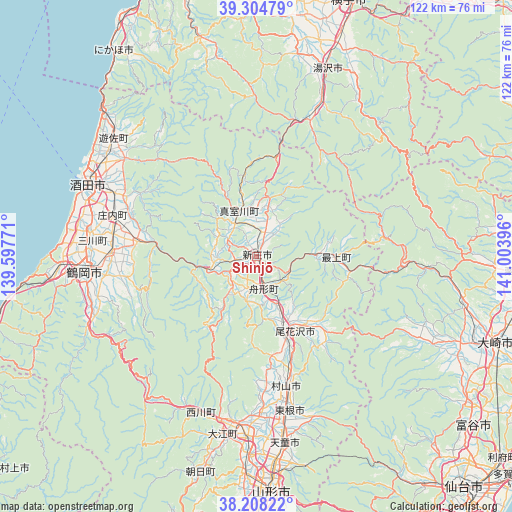
Shinjō GPS coordinates[2]
38° 45' 30.996" North, 140° 18' 2.988" East
| Map corner | latitude | longitude |
|---|---|---|
| Upper-left | 39.30479°, | 139.59771° |
| Center: | 38.75861°, | 140.30083° |
| Lower-right: | 38.20822°, | 141.00396° |
| Map W x H: | 121.9×121.9 km | = 75.7×75.7mi |
| max Lat: | 45.40944° ⇑9.7% North |
| Shinjō: | 38.75861° |
| min Lat: | ⇓90.3% South 24.34478° |
| min Long | Shinjō | max Long |
| 123° | 140.30083° | 145.575° |
| W 83.2%⇐ | ⇒16.8% E |
Elevation
Elevation of Shinjō is 99 m = 325 ft, and this is 14.4 m = 47 ft above average elevation for this country.
| Max E: |
1086 m = 3563 ft | 24.2% |
| Shinjō | 99 m 325 ft | |
| Avg. | 84.6 m = 278 ft | |
Min E: |
-2 m = -7 ft | 75.8% |
See also: Shinjō elevation on elevation.city.
Geographical zone
Shinjō is located in North temperate zone (between Tropic of Cancer and the Arctic Circle). Distance of this Northern Tropic circle is 1703.6 km =1058.6 mi to South.| Distance of | km | miles | from Shinjō |
|---|---|---|---|
| North Pole | 5697.5 | 3540.3 | to North |
| Arctic Circle | 3091.6 | 1921 | to North |
| Tropic Cancer | 1703.6 | 1058.6 | to South |
| Equator | 4309.6 | 2677.9 | to South |


Nearby cities:
15 places around Shinjō: (largest is in red/bold)
• Furukawa
60.5 km =37.6 mi,  110°
110°
• Higashine
36.6 km =22.7 mi,  166°
166°
• Kurihara
60.6 km =37.7 mi,  90°
90°
• Murayama
33.6 km =20.9 mi,  162°
162°
• Nikaho
64.9 km =40.3 mi,  331°
331°
• Obanazawa
19.4 km =12.1 mi,  153°
153°
• Sagae
43 km =26.7 mi,  183°
183°
• Sakata
42.4 km =26.3 mi,  294°
294°
• Tendō
45.4 km =28.2 mi, 172°
• Tomiya
65.1 km =40.5 mi,  128°
128°
• Tsuruoka
41.8 km =26 mi,  264°
264°
• Yamagata
58.7 km =36.5 mi, 174°
• Yuza
43 km =26.7 mi,  311°
311°
• Yuzawa
48.5 km =30.1 mi,  20°
20°
• Ōsaki
61.3 km =38.1 mi, 107°
Sources, notices
• [Note1] Compared only with cities in Japan existing in our database
• [Src1] Map data: © OpenStreetMap contributors (CC-BY-SA)
• [Src2] Other city data from geonames.org with taken over terms of usage.
• [Src3] Geographical zone / Annual Mean Temperature by Robert A. Rohde @ Wikipedia
