Omitama geodata
Omitama (Ibaraki) is a seat of a second-order administrative division; located in Japan in Asia/Tokyo (GMT+9) time zone. In our database, there are 767 cities with bigger population. Compared to other cities in Japan, 72.8% of cities are located further ↓South; 84.5% of cities are located further ←West and 51.1% of cities have higher elevation than Omitama. Note1


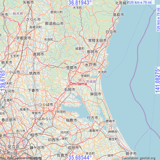
Omitama GPS coordinates[2]
36° 15' 16.164" North, 140° 22' 46.632" East
| Map corner | latitude | longitude |
|---|---|---|
| Upper-left | 36.81943°, | 139.6765° |
| Center: | 36.25449°, | 140.37962° |
| Lower-right: | 35.68544°, | 141.08275° |
| Map W x H: | 126.1×126.1 km | = 78.4×78.4mi |
| max Lat: | 45.40944° ⇑27.2% North |
| Omitama: | 36.25449° |
| min Lat: | ⇓72.8% South 24.34478° |
| min Long | Omitama | max Long |
| 123° | 140.37962° | 145.575° |
| W 84.5%⇐ | ⇒15.5% E |
Elevation
Elevation of Omitama is 27 m = 89 ft, and this is 57.6 m = 189 ft below average elevation for this country.
| Max E: |
1086 m = 3563 ft | 51.1% |
| Avg. | 84.6 m = 278 ft | |
| Omitama | 27 m = 89 ft | |
Min E: |
-2 m = -7 ft | 48.9% |
See also: Japan elevation on elevation.city.
Geographical zone
Omitama is located in North temperate zone (between Tropic of Cancer and the Arctic Circle). Distance of this Northern Tropic circle is 1425.2 km =885.6 mi to South.| Distance of | km | miles | from Omitama |
|---|---|---|---|
| North Pole | 5975.9 | 3713.3 | to North |
| Arctic Circle | 3370.1 | 2094.1 | to North |
| Tropic Cancer | 1425.2 | 885.6 | to South |
| Equator | 4031.1 | 2504.8 | to South |


Nearby cities:
15 places around Omitama: (largest is in red/bold)
• Hitachi-Naka
21 km =13 mi,  41°
41°
• Hokota
16.9 km =10.5 mi,  133°
133°
• Ishioka
12.9 km =8 mi,  232°
232°
• Iwase
27.2 km =16.9 mi,  292°
292°
• Kasama
17.5 km =10.9 mi,  324°
324°
• Kasumigaura
16.4 km =10.2 mi, 226°
• Katsuta
19.9 km =12.4 mi, 43°
• Makabe
25.1 km =15.6 mi,  273°
273°
• Mito
12.4 km =7.7 mi,  30°
30°
• Okunoya
4.6 km =2.9 mi,  46°
46°
• Sakuragawa
23.7 km =14.7 mi, 268°
• Tomobe
12.8 km =8 mi,  326°
326°
• Tsuchiura
23.7 km =14.7 mi,  219°
219°
• Tsukuba
25.8 km =16 mi,  256°
256°
• Ōarai
19.5 km =12.1 mi,  70°
70°
Sources, notices
• [Note1] Compared only with cities in Japan existing in our database
• [Src1] Map data: © OpenStreetMap contributors (CC-BY-SA)
• [Src2] Other city data from geonames.org with taken over terms of usage.
• [Src3] Geographical zone / Annual Mean Temperature by Robert A. Rohde @ Wikipedia
