Hachinohe geodata
Hachinohe (Aomori) is a seat of a second-order administrative division; located in Japan in Asia/Tokyo (GMT+9) time zone. With population of 239,046 people, there are 86 cities with bigger population in this country. Compared to other cities in Japan, 94% of cities are located further ↓South; 95.7% of cities are located further ←West and 59.1% of cities have higher elevation than Hachinohe. Note1


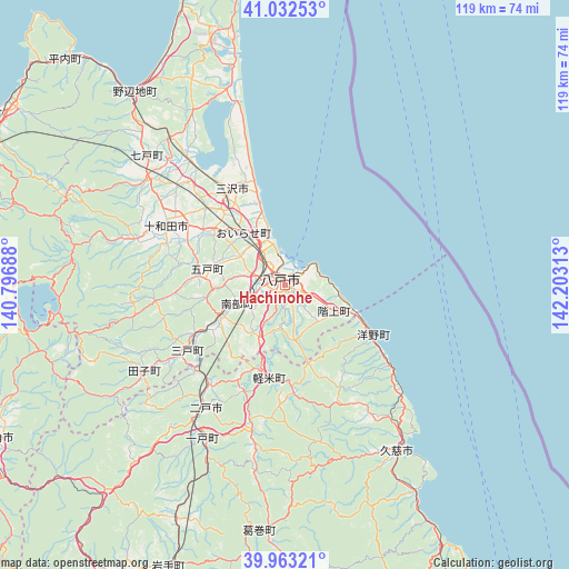
Hachinohe GPS coordinates[2]
40° 30' 0" North, 141° 30' 0" East
| Map corner | latitude | longitude |
|---|---|---|
| Upper-left | 41.03253°, | 140.79688° |
| Center: | 40.5°, | 141.5° |
| Lower-right: | 39.96321°, | 142.20313° |
| Map W x H: | 118.9×118.9 km | = 73.9×73.9mi |
| max Lat: | 45.40944° ⇑6% North |
| Hachinohe: | 40.5° |
| min Lat: | ⇓94% South 24.34478° |
| min Long | Hachinohe | max Long |
| 123° | 141.5° | 145.575° |
| W 95.7%⇐ | ⇒4.3% E |
Elevation
Elevation of Hachinohe is 20 m = 66 ft, and this is 64.6 m = 212 ft below average elevation for this country.
| Max E: |
1086 m = 3563 ft | 59.1% |
| Avg. | 84.6 m = 278 ft | |
| Hachinohe | 20 m = 66 ft | |
Min E: |
-2 m = -7 ft | 40.9% |
See also: Hachinohe elevation on elevation.city.
Geographical zone
Hachinohe is located in North temperate zone (between Tropic of Cancer and the Arctic Circle). Distance of this Northern Tropic circle is 1897.3 km =1178.9 mi to South.| Distance of | km | miles | from Hachinohe |
|---|---|---|---|
| North Pole | 5503.9 | 3420 | to North |
| Arctic Circle | 2898 | 1800.7 | to North |
| Tropic Cancer | 1897.3 | 1178.9 | to South |
| Equator | 4503.2 | 2798.2 | to South |


Nearby cities:
15 places around Hachinohe: (largest is in red/bold)
• Aomori
73.6 km =45.7 mi,  298°
298°
• Furudate
16.8 km =10.4 mi,  281°
281°
• Hachimantai
73.8 km =45.9 mi,  205°
205°
• Hanawa
69.9 km =43.4 mi,  239°
239°
• Hirakawa
79.1 km =49.2 mi, 277°
• Ichinohe
35.9 km =22.3 mi, 209°
• Inuotose
18.5 km =11.5 mi,  307°
307°
• Kazuno
68.9 km =42.8 mi, 241°
• Kuji
41.5 km =25.8 mi,  146°
146°
• Kuroishi
68.5 km =42.6 mi, 280°
• Kuroishi
79.1 km =49.2 mi, 281°
• Misawa
22.8 km =14.2 mi,  335°
335°
• Namioka
80.3 km =49.9 mi,  286°
286°
• Ninohe
28.1 km =17.5 mi, 214°
• Towada
27.9 km =17.3 mi, 298°
Sources, notices
• [Note1] Compared only with cities in Japan existing in our database
• [Src1] Map data: © OpenStreetMap contributors (CC-BY-SA)
• [Src2] Other city data from geonames.org with taken over terms of usage.
• [Src3] Geographical zone / Annual Mean Temperature by Robert A. Rohde @ Wikipedia
