Wote geodata
Wote (Makueni) is a seat of a first-order administrative division; located in Kenya in Africa/Nairobi (GMT+3) time zone. With population of 6,133 people, there are 81 cities with bigger population in this country. Compared to other cities in Kenya, 81.6% of cities are located further ↑North; 73.7% of cities are located further ←West and 75.4% of cities have higher elevation than Wote. Note1


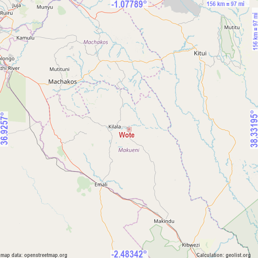
Wote GPS coordinates[2]
1° 46' 50.844" South, 37° 37' 43.752" East
| Map corner | latitude | longitude |
|---|---|---|
| Upper-left | -1.07789°, | 36.9257° |
| Center: | -1.78079°, | 37.62882° |
| Lower-right: | -2.48342°, | 38.33195° |
| Map W x H: | 156.3×156.3 km | = 97.1×97.1mi |
| max Lat: | 3.93726° ⇑81.6% North |
| Wote: | -1.78079° |
| min Lat: | ⇓18.4% South -4.64756° |
| min Long | Wote | max Long |
| 33.97248° | 37.62882° | 41.85688° |
| W 73.7%⇐ | ⇒26.3% E |
Elevation
Elevation of Wote is 1128 m = 3701 ft, and this is 218.7 m = 718 ft below average elevation for this country.
| Max E: |
2514 m = 8248 ft | 75.4% |
| Avg. | 1346.7 m = 4418 ft | |
| Wote | 1128 m = 3701 ft | |
Min E: |
7 m = 23 ft | 24.6% |
See also: Kenya elevation on elevation.city.
Geographical zone
Wote is located in South Torrid zone (between Equator and Tropic of Capricorn). Distance of Equator is 198 km =123 mi to North.| Distance of | km | miles | from Wote |
|---|---|---|---|
| Equator | 198 | 123 | to North |
| Tropic Capricorn | 2407.9 | 1496.2 | to South |
| Antarctic Circle | 7203.2 | 4475.9 | to South |
| South Pole | 9809.1 | 6095.1 | to South |


Nearby cities:
15 places around Wote: (largest is in red/bold)
• Athi River
80.8 km =50.2 mi,  296°
296°
• Kajiado
95 km =59 mi,  265°
265°
• Kandara
120.4 km =74.8 mi,  324°
324°
• Kangundo
61.6 km =38.3 mi,  329°
329°
• Kiambu
111.2 km =69.1 mi,  307°
307°
• Kitui
62.6 km =38.9 mi,  42°
42°
• Konza
55.4 km =34.4 mi, 274°
• Machakos
49.6 km =30.8 mi, 305°
• Makueni Boma
2.6 km =1.6 mi,  191°
191°
• Mtito Andei
117.4 km =72.9 mi,  149°
149°
• Mwingi
105.4 km =65.5 mi,  27°
27°
• Nairobi
105.9 km =65.8 mi, 301°
• Ngong
116.7 km =72.5 mi,  294°
294°
• Pumwani
102.7 km =63.8 mi, 302°
• Thika
103.8 km =64.5 mi, 323°
Sources, notices
• [Note1] Compared only with cities in Kenya existing in our database
• [Src1] Map data: © OpenStreetMap contributors (CC-BY-SA)
• [Src2] Other city data from geonames.org with taken over terms of usage.
• [Src3] Geographical zone / Annual Mean Temperature by Robert A. Rohde @ Wikipedia
