Magadi geodata
Magadi (Kajiado) is a populated place; located in Kenya in Africa/Nairobi (GMT+3) time zone. With population of 14,529 people, there are 52 cities with bigger population in this country. Compared to other cities in Kenya, 84.2% of cities are located further ↑North; 55.3% of cities are located further →East and 83.3% of cities have higher elevation than Magadi. Note1


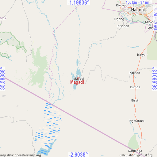
Magadi GPS coordinates[2]
1° 54' 4.392" South, 36° 17' 13.2" East
| Map corner | latitude | longitude |
|---|---|---|
| Upper-left | -1.19836°, | 35.58388° |
| Center: | -1.90122°, | 36.287° |
| Lower-right: | -2.6038°, | 36.99013° |
| Map W x H: | 156.3×156.3 km | = 97.1×97.1mi |
| max Lat: | 3.93726° ⇑84.2% North |
| Magadi: | -1.90122° |
| min Lat: | ⇓15.8% South -4.64756° |
| min Long | Magadi | max Long |
| 33.97248° | 36.287° | 41.85688° |
| W 44.7%⇐ | ⇒55.3% E |
Elevation
Elevation of Magadi is 617 m = 2024 ft, and this is 729.7 m = 2394 ft below average elevation for this country.
| Max E: |
2514 m = 8248 ft | 83.3% |
| Avg. | 1346.7 m = 4418 ft | |
| Magadi | 617 m = 2024 ft | |
Min E: |
7 m = 23 ft | 16.7% |
See also: Kenya elevation on elevation.city.
Geographical zone
Magadi is located in South Torrid zone (between Equator and Tropic of Capricorn). Distance of Equator is 211.4 km =131.4 mi to North.| Distance of | km | miles | from Magadi |
|---|---|---|---|
| Equator | 211.4 | 131.4 | to North |
| Tropic Capricorn | 2394.5 | 1487.9 | to South |
| Antarctic Circle | 7189.8 | 4467.5 | to South |
| South Pole | 9795.7 | 6086.8 | to South |


Nearby cities:
15 places around Magadi: (largest is in red/bold)
• Athi River
91.4 km =56.8 mi,  57°
57°
• Kajiado
54.7 km =34 mi,  84°
84°
• Kangundo
135.4 km =84.1 mi, 60°
• Kiambu
101.5 km =63.1 mi,  36°
36°
• Kijabe
112.2 km =69.7 mi,  16°
16°
• Kikuyu
84 km =52.2 mi,  29°
29°
• Konza
95.6 km =59.4 mi, 79°
• Limuru
96.1 km =59.7 mi, 24°
• Machakos
116.6 km =72.5 mi,  68°
68°
• Nairobi
90.5 km =56.2 mi, 40°
• Naivasha
133 km =82.6 mi,  6°
6°
• Narok
102.3 km =63.6 mi,  333°
333°
• Ngong
74.4 km =46.2 mi, 34°
• Pumwani
92.9 km =57.7 mi, 42°
• Thika
129.9 km =80.7 mi, 42°
Sources, notices
• [Note1] Compared only with cities in Kenya existing in our database
• [Src1] Map data: © OpenStreetMap contributors (CC-BY-SA)
• [Src2] Other city data from geonames.org with taken over terms of usage.
• [Src3] Geographical zone / Annual Mean Temperature by Robert A. Rohde @ Wikipedia
