Athi River geodata
Athi River (Machakos) is a populated place; located in Kenya in Africa/Nairobi (GMT+3) time zone. With population of 24,530 people, there are 39 cities with bigger population in this country. Compared to other cities in Kenya, 78.1% of cities are located further ↑North; 59.6% of cities are located further ←West and 54.4% of cities have lower elevation than Athi River. Note1


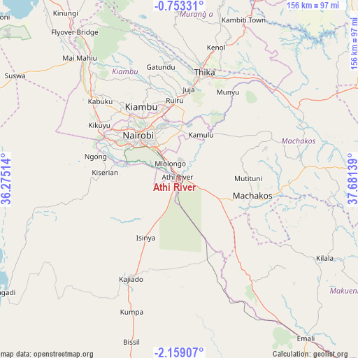
Athi River GPS coordinates[2]
1° 27' 22.68" South, 36° 58' 41.736" East
| Map corner | latitude | longitude |
|---|---|---|
| Upper-left | -0.75331°, | 36.27514° |
| Center: | -1.4563°, | 36.97826° |
| Lower-right: | -2.15907°, | 37.68139° |
| Map W x H: | 156.3×156.3 km | = 97.1×97.1mi |
| max Lat: | 3.93726° ⇑78.1% North |
| Athi River: | -1.4563° |
| min Lat: | ⇓21.9% South -4.64756° |
| min Long | Athi River | max Long |
| 33.97248° | 36.97826° | 41.85688° |
| W 59.6%⇐ | ⇒40.4% E |
Elevation
Elevation of Athi River is 1505 m = 4938 ft, and this is 158.3 m = 519 ft above average elevation for this country.
| Max E: |
2514 m = 8248 ft | 45.6% |
| Athi River | 1505 m 4938 ft | |
| Avg. | 1346.7 m = 4418 ft | |
Min E: |
7 m = 23 ft | 54.4% |
See also: Kenya elevation on elevation.city.
Geographical zone
Athi River is located in South Torrid zone (between Equator and Tropic of Capricorn). Distance of Equator is 161.9 km =100.6 mi to North.| Distance of | km | miles | from Athi River |
|---|---|---|---|
| Equator | 161.9 | 100.6 | to North |
| Tropic Capricorn | 2444 | 1518.6 | to South |
| Antarctic Circle | 7239.2 | 4498.2 | to South |
| South Pole | 9845.1 | 6117.5 | to South |


Nearby cities:
15 places around Athi River: (largest is in red/bold)
• Kajiado
49.4 km =30.7 mi,  206°
206°
• Kandara
62.2 km =38.6 mi,  2°
2°
• Kangundo
44.5 km =27.7 mi,  67°
67°
• Kiambu
35.4 km =22 mi,  333°
333°
• Kijabe
73.6 km =45.7 mi,  322°
322°
• Kikuyu
42.1 km =26.2 mi,  303°
303°
• Konza
35.8 km =22.2 mi,  151°
151°
• Limuru
53.4 km =33.2 mi, 315°
• Machakos
32.7 km =20.3 mi,  102°
102°
• Maragua
75.4 km =46.9 mi,  13°
13°
• Nairobi
26.3 km =16.3 mi, 316°
• Ngong
36.2 km =22.5 mi,  288°
288°
• Pumwani
23.9 km =14.9 mi, 323°
• Thika
48.1 km =29.9 mi, 12°
• Wote
80.8 km =50.2 mi,  116°
116°
Sources, notices
• [Note1] Compared only with cities in Kenya existing in our database
• [Src1] Map data: © OpenStreetMap contributors (CC-BY-SA)
• [Src2] Other city data from geonames.org with taken over terms of usage.
• [Src3] Geographical zone / Annual Mean Temperature by Robert A. Rohde @ Wikipedia
