Machakos geodata
Machakos is a seat of a first-order administrative division; located in Kenya in Africa/Nairobi (GMT+3) time zone. With population of 31,971 people, there are 33 cities with bigger population in this country. Compared to other cities in Kenya, 79.8% of cities are located further ↑North; 68.4% of cities are located further ←West and 60.5% of cities have lower elevation than Machakos. Note1


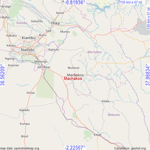
Machakos GPS coordinates[2]
1° 31' 20.388" South, 37° 15' 54.756" East
| Map corner | latitude | longitude |
|---|---|---|
| Upper-left | -0.81936°, | 36.56209° |
| Center: | -1.52233°, | 37.26521° |
| Lower-right: | -2.22507°, | 37.96834° |
| Map W x H: | 156.3×156.3 km | = 97.1×97.1mi |
| max Lat: | 3.93726° ⇑79.8% North |
| Machakos: | -1.52233° |
| min Lat: | ⇓20.2% South -4.64756° |
| min Long | Machakos | max Long |
| 33.97248° | 37.26521° | 41.85688° |
| W 68.4%⇐ | ⇒31.6% E |
Elevation
Elevation of Machakos is 1619 m = 5312 ft, and this is 272.3 m = 893 ft above average elevation for this country.
| Max E: |
2514 m = 8248 ft | 39.5% |
| Machakos | 1619 m 5312 ft | |
| Avg. | 1346.7 m = 4418 ft | |
Min E: |
7 m = 23 ft | 60.5% |
See also: Kenya elevation on elevation.city.
Geographical zone
Machakos is located in South Torrid zone (between Equator and Tropic of Capricorn). Distance of Equator is 169.3 km =105.2 mi to North.| Distance of | km | miles | from Machakos |
|---|---|---|---|
| Equator | 169.3 | 105.2 | to North |
| Tropic Capricorn | 2436.7 | 1514.1 | to South |
| Antarctic Circle | 7231.9 | 4493.7 | to South |
| South Pole | 9837.8 | 6112.9 | to South |


Nearby cities:
15 places around Machakos: (largest is in red/bold)
• Athi River
32.7 km =20.3 mi,  282°
282°
• Kajiado
65.5 km =40.7 mi,  235°
235°
• Kandara
75.4 km =46.9 mi,  337°
337°
• Kangundo
26 km =16.2 mi,  20°
20°
• Kiambu
61.7 km =38.3 mi,  309°
309°
• Kikuyu
73.7 km =45.8 mi,  294°
294°
• Konza
28.3 km =17.6 mi,  211°
211°
• Limuru
82.8 km =51.4 mi,  303°
303°
• Makueni Boma
50.7 km =31.5 mi,  128°
128°
• Maragua
82.1 km =51 mi,  349°
349°
• Nairobi
56.5 km =35.1 mi, 298°
• Ngong
68.8 km =42.8 mi, 285°
• Pumwani
53.3 km =33.1 mi, 299°
• Thika
58.6 km =36.4 mi, 338°
• Wote
49.6 km =30.8 mi, 125°
Sources, notices
• [Note1] Compared only with cities in Kenya existing in our database
• [Src1] Map data: © OpenStreetMap contributors (CC-BY-SA)
• [Src2] Other city data from geonames.org with taken over terms of usage.
• [Src3] Geographical zone / Annual Mean Temperature by Robert A. Rohde @ Wikipedia
