Nyamira geodata
Nyamira is a seat of a first-order administrative division; located in Kenya in Africa/Nairobi (GMT+3) time zone. With population of 10,000 people, there are 68 cities with bigger population in this country. Compared to other cities in Kenya, 53.5% of cities are located further ↑North; 77.2% of cities are located further →East and 83.3% of cities have lower elevation than Nyamira. Note1


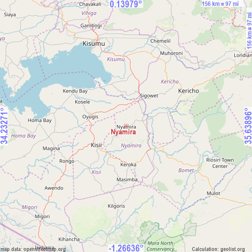
Nyamira GPS coordinates[2]
0° 33' 47.988" South, 34° 56' 8.988" East
| Map corner | latitude | longitude |
|---|---|---|
| Upper-left | 0.13979°, | 34.23271° |
| Center: | -0.56333°, | 34.93583° |
| Lower-right: | -1.26636°, | 35.63896° |
| Map W x H: | 156.3×156.4 km | = 97.1×97.2mi |
| max Lat: | 3.93726° ⇑53.5% North |
| Nyamira: | -0.56333° |
| min Lat: | ⇓46.5% South -4.64756° |
| min Long | Nyamira | max Long |
| 33.97248° | 34.93583° | 41.85688° |
| W 22.8%⇐ | ⇒77.2% E |
Elevation
Elevation of Nyamira is 2000 m = 6562 ft, and this is 653.3 m = 2143 ft above average elevation for this country.
| Max E: |
2514 m = 8248 ft | 16.7% |
| Nyamira | 2000 m 6562 ft | |
| Avg. | 1346.7 m = 4418 ft | |
Min E: |
7 m = 23 ft | 83.3% |
See also: Kenya elevation on elevation.city.
Geographical zone
Nyamira is located in South Torrid zone (between Equator and Tropic of Capricorn). Distance of Equator is 62.6 km =38.9 mi to North.| Distance of | km | miles | from Nyamira |
|---|---|---|---|
| Equator | 62.6 | 38.9 | to North |
| Tropic Capricorn | 2543.3 | 1580.3 | to South |
| Antarctic Circle | 7338.5 | 4559.9 | to South |
| South Pole | 9944.4 | 6179.2 | to South |


Nearby cities:
15 places around Nyamira: (largest is in red/bold)
• Ahero
43.4 km =27 mi,  357°
357°
• Homa Bay
53.4 km =33.2 mi,  274°
274°
• Kericho
44.3 km =27.5 mi,  60°
60°
• Keroka
23.7 km =14.7 mi,  177°
177°
• Kipkelion
71.6 km =44.5 mi, 55°
• Kisii
23 km =14.3 mi,  235°
235°
• Kisumu
54.8 km =34.1 mi,  339°
339°
• Litein
28.3 km =17.6 mi,  94°
94°
• Mbale
75.6 km =47 mi, 341°
• Migori
75.8 km =47.1 mi,  222°
222°
• Muhoroni
53.6 km =33.3 mi,  32°
32°
• Ogembo
35.3 km =21.9 mi, 221°
• Oyugis
23.6 km =14.7 mi,  284°
284°
• Sotik
24.1 km =15 mi,  126°
126°
• Sotik Post
51.2 km =31.8 mi,  118°
118°
Sources, notices
• [Note1] Compared only with cities in Kenya existing in our database
• [Src1] Map data: © OpenStreetMap contributors (CC-BY-SA)
• [Src2] Other city data from geonames.org with taken over terms of usage.
• [Src3] Geographical zone / Annual Mean Temperature by Robert A. Rohde @ Wikipedia
